Difference between revisions of "2008-08-08 -35 138"
From Geohashing
(→About) |
m (More specific location) |
||
| (4 intermediate revisions by 4 users not shown) | |||
| Line 9: | Line 9: | ||
after picking up several other potential Geo#ers we drove to the closes point to the geo#. | after picking up several other potential Geo#ers we drove to the closes point to the geo#. | ||
| − | But it wasn't close enough and after approximately 1km of walking we got to the geo# point at midnight located next to a big dam | + | But it wasn't close enough and after approximately 1km of walking we got to the geo# point at midnight located next to a big dam which we explored after we completed the hash. |
== People == | == People == | ||
| Line 18: | Line 18: | ||
== Photos == | == Photos == | ||
| − | + | <gallery widths="200px" heights="160px" perrow="2"> | |
| − | [[ | + | Image:080808_DamFromHashPoint.JPG|View looking up at the dam from the hash point |
| + | </gallery> | ||
| + | |||
| + | |||
| + | [[Category:Expeditions]] | ||
| + | [[Category:Expeditions with photos]] | ||
| + | [[Category:Coordinates reached]] | ||
| + | {{location|AU|SA|MI}} | ||
Latest revision as of 11:24, 1 August 2020
| Fri 8 Aug 2008 in -35,138: -35.0416712, 138.5910683 geohashing.info google osm bing/os kml crox |
About
after picking up several other potential Geo#ers we drove to the closes point to the geo#.
But it wasn't close enough and after approximately 1km of walking we got to the geo# point at midnight located next to a big dam which we explored after we completed the hash.
People
one group turned up at 12:00ish
- Nathan
- BobTheFish
- and friends
Photos
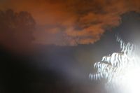
View looking up at the dam from the hash point
