Difference between revisions of "2008-11-04 47 -122"
imported>Thomcat (Expedition and photos) |
(fFbenO <a href="http://cwqaxtcrvbqm.com/">cwqaxtcrvbqm</a>, [url=http://atdqtjowixco.com/]atdqtjowixco[/url], [link=http://rjqfnoltujfg.com/]rjqfnoltujfg[/link], http://wptbfxbhhwip.com/) |
||
| Line 8: | Line 8: | ||
}} | }} | ||
| − | == | + | fFbenO <a href="http://cwqaxtcrvbqm.com/">cwqaxtcrvbqm</a>, [url=http://atdqtjowixco.com/]atdqtjowixco[/url], [link=http://rjqfnoltujfg.com/]rjqfnoltujfg[/link], http://wptbfxbhhwip.com/ |
| − | |||
| − | |||
== Expedition == | == Expedition == | ||
Revision as of 09:08, 10 October 2009
| Tue 4 Nov 2008 in Seattle: 47.9050661, -122.1353791 geohashing.info google osm bing/os kml crox |
fFbenO <a href="http://cwqaxtcrvbqm.com/">cwqaxtcrvbqm</a>, [url=http://atdqtjowixco.com/]atdqtjowixco[/url], [link=http://rjqfnoltujfg.com/]rjqfnoltujfg[/link], http://wptbfxbhhwip.com/
Expedition
Just a short jaunt north from my work leads me to the spot, and my first geohash in two and a half weeks. Apparently there are big plans for this stretch of fields someday. I just hope they consider that this river does flood on occasion.
Back to the Future?

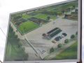
According to the satellite, a nice dirt road leads to a good parking spot less than 500 feet away, and this proves to be correct. I though to myself, "Strange - there's a windsock and two chemical toilets in the field." Reaching the signboard, I found this to be the home of the Cascade Model Helicopter Club. The actual spot was not far from the sign. After snapping a few photos, I left a calling card on their message board - The Internet Was Here.


To Model Helicopter enthusiasts who find this - hello! Feel free to click on the "discussion" tab above and say hello back, and thanks for letting me walk onto your field. :)