Difference between revisions of "2008-11-19 48 9"
imported>Ekorren (Yay for Consecutive geohash ;)) |
imported>Ekorren m (typos) |
||
| Line 16: | Line 16: | ||
are the odds to get them ''twice in a row'' and ''three times within of five days''? Let's just say: Yay for [[Consecutive Geohash]]! | are the odds to get them ''twice in a row'' and ''three times within of five days''? Let's just say: Yay for [[Consecutive Geohash]]! | ||
| − | I left home around a quarter past twelve and headed for the Neckar valley. There is a good cycle trail in that valley which I travelled countless times before and would be able to go | + | I left home around a quarter past twelve and headed for the Neckar valley. There is a good cycle trail in that valley which I travelled countless times before and would be able to go blindfolded (actually I did that once last winter - trying to get home in the dark during heavy snowfall is effectively the same). Left the Neckar valley at Kirchentellinsfurt to follow the Echaz up, stopped twice to shop some food, and reached Wannweil with nothing remarkable having happened up to now. After a ten minutes fight with a 13% slope (no fear, first gear, and I won) I got to the peak where the hashpoint was. |
| − | I was not entirely sure whether I should go for ''coordinates reached'', ''[[Restricted Area Geohash|restricted area]]'' or even ''[[MNB Geohash|MNB]]''. The exact coordinates may be within of the bushes that border the private backyard of the gardener who owns that place. It wouldn't be | + | I was not entirely sure whether I should go for ''coordinates reached'', ''[[Restricted Area Geohash|restricted area]]'' or even ''[[MNB Geohash|MNB]]''. The exact coordinates may be within of the bushes that border the private backyard of the gardener who owns that place. It wouldn't be possible to reach that exact point from the other side either, and still, the distance is far below the accuracy of both GPS and Google Maps, so the ppoint could just as well be on the public agricultural way along the bushes. So I'll count them as reached for now. I put the marker into the bushes, made another one from sticks on the way, took photos and left. |
| − | Then I continued to | + | Then I continued to some villages nearby to search for remains of the Reutlingen suburban tramway which was closed in the 1970s, but didn't find anything I didn't already know. Finally I went for one geocache at least, which turned out to be too small to hold the things I wanted to put in there, and I shouldn't have taken the way described in the listing... |
When back on paved ways, I noticed that my back tyre had lost significant amounts of air (and it actually ''is'' one of those kevlar-reinforced thorn repellant tyres...) but luckily I had a pump with me, so I made it home with several pumping stops but without shunting or taking a train. | When back on paved ways, I noticed that my back tyre had lost significant amounts of air (and it actually ''is'' one of those kevlar-reinforced thorn repellant tyres...) but luckily I had a pump with me, so I made it home with several pumping stops but without shunting or taking a train. | ||
| − | Total distance cycled: 36.72 km, whereof | + | Total distance cycled: 36.72 km, whereof approximately 1 km cross country and 12 km with a half-flat tyre. |
<gallery perrow="3"> | <gallery perrow="3"> | ||
| Line 31: | Line 31: | ||
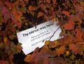
Image:2008-11-19-48-9-road.jpg|There wasn't such a sign at the lower end. | Image:2008-11-19-48-9-road.jpg|There wasn't such a sign at the lower end. | ||
Image:2008-11-19-48-9-marker.jpg|The obligatory marker | Image:2008-11-19-48-9-marker.jpg|The obligatory marker | ||
| − | Image:2008-11-19-48-9-instruments.jpg|Date and coordinates are right | + | Image:2008-11-19-48-9-instruments.jpg|Date and coordinates are right |
</gallery> | </gallery> | ||
| Line 51: | Line 51: | ||
[[Category:Expeditions]] | [[Category:Expeditions]] | ||
| − | [[Category: | + | [[Category:Coordinates reached]] |
[[Category:Expeditions with photos]] | [[Category:Expeditions with photos]] | ||
Revision as of 17:29, 19 November 2008
| Wed 19 Nov 2008 in Stuttgart, Germany: 48.5198710, 9.1615679 geohashing.info google osm bing/os kml crox |
About
The hashpoint is at a gardeners place at Wannweil, above the village near the road to Degerschlacht.
It's remarkable that the location is only about 2.5 km from past saturday's, and 4 km from yesterday's (direct line - about twice that distance using paved ways).
Expedition: Ekorren
With approximately 8182 km² as the size of a graticule of this latitude, the probability to get coordinates within of a 10 km (direct line) radius around ones home is pretty low: 3.84%. Substract water, steep terrain and restricted areas, one may expect such a near hashpoint roughly once per month. So, what are the odds to get them twice in a row and three times within of five days? Let's just say: Yay for Consecutive Geohash!
I left home around a quarter past twelve and headed for the Neckar valley. There is a good cycle trail in that valley which I travelled countless times before and would be able to go blindfolded (actually I did that once last winter - trying to get home in the dark during heavy snowfall is effectively the same). Left the Neckar valley at Kirchentellinsfurt to follow the Echaz up, stopped twice to shop some food, and reached Wannweil with nothing remarkable having happened up to now. After a ten minutes fight with a 13% slope (no fear, first gear, and I won) I got to the peak where the hashpoint was.
I was not entirely sure whether I should go for coordinates reached, restricted area or even MNB. The exact coordinates may be within of the bushes that border the private backyard of the gardener who owns that place. It wouldn't be possible to reach that exact point from the other side either, and still, the distance is far below the accuracy of both GPS and Google Maps, so the ppoint could just as well be on the public agricultural way along the bushes. So I'll count them as reached for now. I put the marker into the bushes, made another one from sticks on the way, took photos and left.
Then I continued to some villages nearby to search for remains of the Reutlingen suburban tramway which was closed in the 1970s, but didn't find anything I didn't already know. Finally I went for one geocache at least, which turned out to be too small to hold the things I wanted to put in there, and I shouldn't have taken the way described in the listing...
When back on paved ways, I noticed that my back tyre had lost significant amounts of air (and it actually is one of those kevlar-reinforced thorn repellant tyres...) but luckily I had a pump with me, so I made it home with several pumping stops but without shunting or taking a train.
Total distance cycled: 36.72 km, whereof approximately 1 km cross country and 12 km with a half-flat tyre.
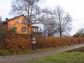
Somewhere at this row of bushes
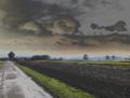
View from the hashpoint (slightly digitally enhanced)

There wasn't such a sign at the lower end.
The obligatory marker
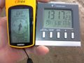
Date and coordinates are right


Ekorren earned the Bicycle geohash achievement
|
Ekorren earned the Consecutive geohash achievement
|