Difference between revisions of "2009-02-11 33 -84"
From Geohashing
imported>Woodveil (New page: {{meetup graticule | map=<map lat="33" lon="-84" date="2009-02-11" /> | lat=33 | lon=-84 | date=2009-02-11 | graticule_name=Atlanta | graticule_link=Atlanta, Georgia }} == About == These...) |
imported>Woodveil (→Achievements) |
||
| Line 34: | Line 34: | ||
== Achievements == | == Achievements == | ||
| − | {{land geohash | latitude = 33 | longitude = -84 | date = 2009- | + | {{land geohash | latitude = 33 | longitude = -84 | date = 2009-02-11 | name = [[user:NWoodruff|NWoodruff]] and [[user:Woodveil|Woodveil]]}} |
{{Speed Racer geohash | latitude = 33 | longitude = -84 | date = 2009-02-11 | name = [[user:NWoodruff|NWoodruff]] and [[user:Woodveil|Woodveil]]}} | {{Speed Racer geohash | latitude = 33 | longitude = -84 | date = 2009-02-11 | name = [[user:NWoodruff|NWoodruff]] and [[user:Woodveil|Woodveil]]}} | ||
Revision as of 18:59, 11 February 2009
| Wed 11 Feb 2009 in Atlanta: 33.6545786, -84.0082915 geohashing.info google osm bing/os kml crox |
About
These coordinates were in the far East of the graticule, and were directly on I20! In an Eastbound lane, just after an onramp (Exit 82, in case you were wondering). Not that it mattered much, but weather was ~68°F and overcast.
Expedition
Woodveil
We had a break in classes and hit up the point a few minutes after 1:00. It took us a couple runs to get satisfactory evidence, and even then the closest reading we could photograph is 13.3 feet. It takes a little more timing when you're going 65 miles per hour. But what the hell, it was fun.
NWoodruff
Coming soon!
Gallery
- Photo Gallery
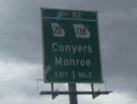
The hash was in Conyers, Georgia.
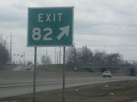
Yep, 82.
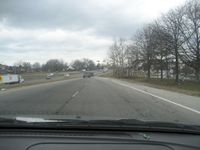
The onramp in question.
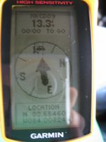
GPS proof. If speed were displayed, it'd have shown about 65 mph.


Achievements
NWoodruff and Woodveil earned the Land geohash achievement
|

by passing through the (33, -84) geohash on 2009-02-11 at the maximum legal speed.