Difference between revisions of "2009-02-21 46 -122"
imported>New User (added categories) |
imported>Jiml m (Adjust sections) |
||
| Line 1: | Line 1: | ||
{{meetup graticule | {{meetup graticule | ||
| − | |||
| lat=46 | | lat=46 | ||
| lon=-122 | | lon=-122 | ||
| Line 8: | Line 7: | ||
}} | }} | ||
| − | == | + | ==Location== |
| + | On the fringe of a tiny town called Tenino, where a pasture borders a forest. | ||
| − | + | ==Participants== | |
| + | *[[User:New User|New User]] | ||
==[[User:New User|New User]]'s Expedition== | ==[[User:New User|New User]]'s Expedition== | ||
Revision as of 06:00, 31 January 2010
| Sat 21 Feb 2009 in Mt. St. Helens: 46.8655206, -122.8235131 geohashing.info google osm bing/os kml crox |
Location
On the fringe of a tiny town called Tenino, where a pasture borders a forest.
Participants
New User's Expedition
This was my first Geohash, and it wasn't even in my home graticule. Early this morning was the first time I heard about xkcd's Geohashing, but when I read about it I decided that it sounded like fun, and I really needed to get out of the house.
That was about 7:00 AM. I didn't reach the hash until 4:36 PM because I didn't own a handheld GPS and it was a pain to find a retailer that had a decent model in my price range.
Once I obtained the GPS, I proceeded with the journey. After a recon from Google maps, I decided it was much less of a journey to go to the graticule south of my location. It looked easy enough, as Google clearly shows the marker near the edge of the forest. I undertook this journey with only the GPS, my digital camera (which was a fancy new model when I bought it six years ago), and the Google driving directions written in my logbook because I am currently without a printer.
Once I was close to the site, I had a decision to make. I could ask the nearby horse rancher for permission to park on his land and walk along the outside of his pasture's fence, or park on the side of the road somewhere and walk through the small leg of woods. I decided for the latter, because I knew I wasn't likely to meet any other Geohashers and so I might as well have some fun romping through the wood. It turned out to be the most thickly grown vegetation I have ever fought my way through, but fight I did, and valiantly so. I was unfamiliar with the workings of a handheld GPS receiver (or any GPS receiver for that matter) so it took me some zig-zagging to finally make it to the hash coordinates.
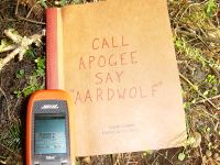
I never was much for photography (the six-year-old digital camera I have has hardly been used) so the only pictures I took by the rays of the setting sun were of my GPS data, with my logbook's catchphrase nearby. Maybe I should have chosen DON'T PANIC, because as soon as I snapped the photos I quickly made for my car for fear that the horse rancher should decide to release the hounds, and for fear of car vandals as well.
There wasn't really anything interesting to see on the journey. The most interesting things were animal droppings (I think I identified three different kinds of droppings, but who knows? I'm not much of an outdoorsman) and animal footprints, at least one set of which was from a deer.
