Difference between revisions of "2009-03-07 35 -78"
From Geohashing
imported>Ncbears (add hash) |
imported>Jiml m (Appease APBot) |
||
| Line 1: | Line 1: | ||
__NOTOC__ | __NOTOC__ | ||
{{meetup graticule | {{meetup graticule | ||
| − | |||
| lat=35 | | lat=35 | ||
| lon=-78 | | lon=-78 | ||
| date=2009-03-07 | | date=2009-03-07 | ||
}} | }} | ||
| + | |||
| + | == Location== | ||
| + | Hash was about 405 meters from the edge of a road into a field. | ||
| + | |||
| + | |||
==Report== | ==Report== | ||
| − | + | We scouted the area on our way home from the [[2009-03-06_35_-78|Geohash last night]] and decided upon a sunrise attempt since the field faced east. | |
Several deer footy prints indicated we were not the first geohashers. | Several deer footy prints indicated we were not the first geohashers. | ||
Revision as of 06:41, 18 March 2011
| Sat 7 Mar 2009 in 35,-78: 35.9505124, -78.3216363 geohashing.info google osm bing/os kml crox |
Location
Hash was about 405 meters from the edge of a road into a field.
Report
We scouted the area on our way home from the Geohash last night and decided upon a sunrise attempt since the field faced east. Several deer footy prints indicated we were not the first geohashers.
Participants
Eisen & Bear - NCBears
Geological Features
Rolling pasture, residential/farmland.
Wildlife Encounters
Robins in field, geese overhead, deer paw prints
Weather
51.1°F/10.6°C, clear skies, light breeze
Pictures
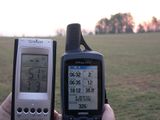
Saturday morning Geohash.
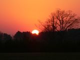
Beautiful sunrise
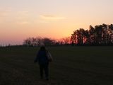
Sunrise Bear

On the nose

’cuse me Ma’am, did you lose a hubby cap?


