Difference between revisions of "Alert Bay, British Columbia"
imported>Dunstergirl |
imported>Fippe |
||
| Line 48: | Line 48: | ||
| − | [[Category: | + | [[Category:Inactive graticules]] |
[[Category:British Columbia]] | [[Category:British Columbia]] | ||
Revision as of 20:06, 15 August 2018
| Dawsons Landing | Wawwat'l Indian Reserve 12 | Sim Creek Indian Reserve 5 |
| Port Hardy | Alert Bay | Campbell River |
| Tatchu Reserve | Gold River | Courtenay |
|
Today's location: not yet announced | ||
The Alert Bay graticule (50,-126) encompasses part of the northwestern end of Vancouver Island, the Broughton Archipelago at the western end of Johnstone Strait, and a bit of mainland BC. It includes the communities of Alert Bay on Cormorant Island, Telegraph Cove and Woss on Vancouver Island, and a few smaller, mostly remote settlements scattered on islands (including Kaleva and Mitchell Bay on Malcolm Island) and the mainland. The region's abundant wildlife (whales, sea lions, dolphins, bald eagles and more!), cultural attractions (Alert Bay boasts the world's tallest totem pole), and great fishing draw tourists in summer, while fishing and logging remain key components of the region's economy. Today's location
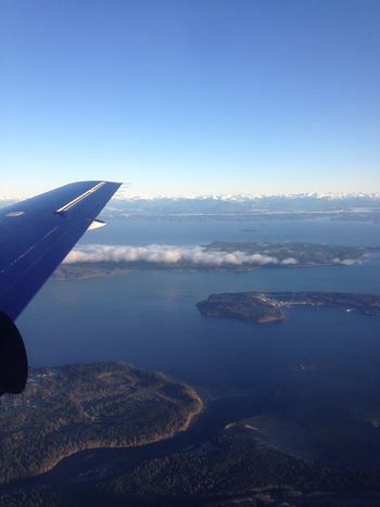
Photo looking northwest from Vancouver Island (mouth of the Nimpkish River) at Cormorant Island (foreground), Malcolm Island (middle), and the BC mainland in the distance.
Local Geohashers
Expeditions
Notable Dates
- 2016-06-28: Dunstergirl achieves the first hash in this graticule
