Difference between revisions of "2009-05-08 67 19"
imported>The ru |
imported>The ru |
||
| Line 6: | Line 6: | ||
}} | }} | ||
| + | The hashpoint was on a mountain, about halfway between Akkar and Pirttivuopio, 1.5 km north of the road. | ||
| + | == [[User:the_ru|the ru]] == | ||
| + | I started out around 4 PM, drove towards Nikkaluokta. I parked 1.8 km from the hashpoint, a little bit to the east, next to a "rengärde" (a fenced-in area where they gather reindeer for marking and slaughter). | ||
| + | |||
| + | Google showed at least 200 m elevation difference, so it was a steep climb. There were a couple of low hills before I reached the actual mountain. After a kilometer I was above the treeline and reached a plateau I could follow to the hash. | ||
| + | |||
| + | Most of the snow was gone but not entirely (more at the higher altitudes). The hashpoint was still snow-covered. | ||
| + | |||
| + | After I had been to the hashpoint, I went east along the mountain. At the top, I changed into dry clothes, ate and drank to regain energy, then begun the descent. | ||
| + | |||
| + | I was home again by 8 PM, the expedition had taken much less time than I had expected (!?). | ||
<gallery perrow="4"> | <gallery perrow="4"> | ||
| Line 14: | Line 25: | ||
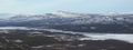
Image:2009-05-08_67_19_kebne.jpg | View towards Kebnekaise | Image:2009-05-08_67_19_kebne.jpg | View towards Kebnekaise | ||
Image:2009-05-08_67_19_summit.jpg | Someone had built this at the summit, I added a couple of stones as well | Image:2009-05-08_67_19_summit.jpg | Someone had built this at the summit, I added a couple of stones as well | ||
| − | Image:2009-05-08_67_19_old_hash.jpg | View southwest over Paittasjärvi, the [[2009-04-20 67 19]] hashpoint | + | Image:2009-05-08_67_19_old_hash.jpg | View southwest over Paittasjärvi, the [[2009-04-20 67 19]] hashpoint was next to that cape |
Image:2009-05-08_67_19_se.jpg | Southeast | Image:2009-05-08_67_19_se.jpg | Southeast | ||
Image:2009-05-08_67_19_mountain.jpg | Hash Mountain | Image:2009-05-08_67_19_mountain.jpg | Hash Mountain | ||
</gallery> | </gallery> | ||
| + | |||
The area had many rather... bizarre trees. They looked like they had snapped at a young age, but kept growing and curled around themselves. They were just below the treeline, so I guess they are stretching the limits on where pinetrees are supposed to grow. | The area had many rather... bizarre trees. They looked like they had snapped at a young age, but kept growing and curled around themselves. They were just below the treeline, so I guess they are stretching the limits on where pinetrees are supposed to grow. | ||
Revision as of 08:09, 9 May 2009
| Fri 8 May 2009 in 67,19: 67.8793001, 19.3943647 geohashing.info google osm bing/os kml crox |
The hashpoint was on a mountain, about halfway between Akkar and Pirttivuopio, 1.5 km north of the road.
the ru
I started out around 4 PM, drove towards Nikkaluokta. I parked 1.8 km from the hashpoint, a little bit to the east, next to a "rengärde" (a fenced-in area where they gather reindeer for marking and slaughter).
Google showed at least 200 m elevation difference, so it was a steep climb. There were a couple of low hills before I reached the actual mountain. After a kilometer I was above the treeline and reached a plateau I could follow to the hash.
Most of the snow was gone but not entirely (more at the higher altitudes). The hashpoint was still snow-covered.
After I had been to the hashpoint, I went east along the mountain. At the top, I changed into dry clothes, ate and drank to regain energy, then begun the descent.
I was home again by 8 PM, the expedition had taken much less time than I had expected (!?).
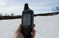
GPS @ the hashpoint
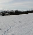
The hashpoint
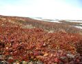
Intense colors
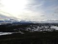
View towards Kebnekaise
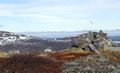
Someone had built this at the summit, I added a couple of stones as well
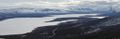
View southwest over Paittasjärvi, the 2009-04-20 67 19 hashpoint was next to that cape
Southeast
Hash Mountain


The area had many rather... bizarre trees. They looked like they had snapped at a young age, but kept growing and curled around themselves. They were just below the treeline, so I guess they are stretching the limits on where pinetrees are supposed to grow.


