Difference between revisions of "2009-09-15 40 -74"
From Geohashing
imported>Knitting Duck (→Plans) |
imported>Knitting Duck |
||
| Line 24: | Line 24: | ||
== Expedition == | == Expedition == | ||
| − | |||
| − | |||
| − | |||
| Line 39: | Line 36: | ||
</gallery> | </gallery> | ||
| + | |||
| + | [[Category:Expedition planning]] | ||
<!-- Potential categories. Please include all the ones appropriate to your expedition --> | <!-- Potential categories. Please include all the ones appropriate to your expedition --> | ||
| − | |||
| − | |||
| − | |||
| − | |||
[[Category:Expeditions]] | [[Category:Expeditions]] | ||
| − | + | [[Category:Expeditions with photos]] | |
| − | [[Category:Expeditions with photos]] | ||
| − | |||
| − | |||
| − | |||
| − | |||
| − | |||
[[Category:Coordinates reached]] | [[Category:Coordinates reached]] | ||
| − | |||
| − | + | ||
[[Category:Coordinates not reached]] | [[Category:Coordinates not reached]] | ||
-- and a reason -- | -- and a reason -- | ||
Revision as of 16:39, 15 September 2009
| Tue 15 Sep 2009 in 40,-74: 40.8586751, -74.3238955 geohashing.info google osm bing/os kml crox |
Location
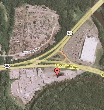
40.858675°, -74.323896°... otherwise known as a parking lot off Bloomfield Avenue near Route 46 in (what I think at that point is) Fairfield, NJ.
Participants
Plans
Knitting Duck
Knitting Duck is going out this afternoon anyway, though not quite in the direction of the hash. It's maybe a fifteen minute detour. Since it looks like it's just in a parking lot, it should be easy enough to drive up, snap a few pictures, and head out again.
Expedition
Photos
-- and a reason -- -->
