Difference between revisions of "2010-02-21 48 11"
imported>Zb (beginning the narrative...) |
imported>Zb m (→Photos: add 1st pic to gallery.) |
||
| Line 37: | Line 37: | ||
--> | --> | ||
<gallery perrow="4"> | <gallery perrow="4"> | ||
| + | Image:2010-02-21 48 11 zb Mammendorf 0016.jpg | Sunrise between Mammendorf and Egg, at the coordiantes. | ||
</gallery> | </gallery> | ||
Revision as of 12:25, 21 February 2010
| Sun 21 Feb 2010 in 48,11: 48.1965597, 11.1560514 geohashing.info google osm bing/os kml crox |
Location
W of München, S of Mammendorf, close to the village of Egg. Easily accessible (train, then walk).
Participants
Plans
Time to 1-up the score for München's graticule!
Y'all, I might be interested in checking out this Sunday's location in München's West, almost revisiting 2009-04-24 48 11 and 2009-04-03 48 11. S-Bahn or RB from München (or RB from Augsburg and beyond) to Mammendorf, then walk. Not sure about the time yet, no other plans for the day (Sundays are awesome!). I could adjust to others' plans, if anyone else wants to go. --Zb 11:45, 20 February 2010 (UTC)--Zb 11:37, 20 February 2010 (UTC)
Tryin' to make it for sunrise. --Zb 03:23, 21 February 2010 (UTC)
Narrative
Zb left the house at 5 am by bike for München's main station, went by train to Mammendorf, arrived at the geohash just before sunrise at 7:09 am, stayed for a bit and then went trainspotting during a long walk via Mammendorf and Haspelmoor to Althegnenberg, where he took the train back to München, arriving home at 12:15 pm. It was beautiful.
Photos
Plenty to come...
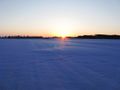
Sunrise between Mammendorf and Egg, at the coordiantes.
