Difference between revisions of "2010-07-24 48 -123"
imported>Jiml m (Planning has occurred! We await the results) |
imported>Wenslayer (Add photos and achievement; write-up to follow...) |
||
| Line 32: | Line 32: | ||
== Photos == | == Photos == | ||
| − | |||
| − | |||
| − | |||
| − | |||
<gallery perrow="5"> | <gallery perrow="5"> | ||
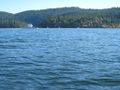
| + | Image:2010-07-24_48_-123_Mill_Bay_Ferry1.jpg | [http://www.bcferries.com/News/mill_bay.html Mill Bay Ferry] leaving Brentwood Bay along with me. | ||
| + | Image:2010-07-24_48_-123_Ardmore_Point_rocks.jpg | A calm place to rest after crossing choppy Coles Bay. | ||
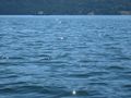
| + | Image:2010-07-24_48_-123_Geohash1.jpg | One of about 4 pictures snapped as I drifted through the Geohash coordinate. | ||
| + | Image:2010-07-24_48_-123_proof.jpg | Cropped and color-modified picture of above showing I made the coordinates. | ||
| + | Image:2010-07-24_48_-123_looking_south.jpg | Looking south from the Geohash location. | ||
| + | Image:2010-07-24_48_-123_looking_north.jpg | Looking north from the Geohash location (the barren hill is on Saltspring Island). | ||
| + | Image:2010-07-24_48_-123_Senanus_Island.jpg | Senanus Island to my right as I paddled back. | ||
| + | Image:2010-07-24_48_-123_war_canoe_race.jpg | The local tribe appeared to be holding war canoe races. | ||
| + | Image:2010-07-24_48_-123_Mill_Bay_Ferry2.jpg | The Mill Bay Ferry heading out again. | ||
| + | Image:2010-07-24_48_-123_Wenslayer.jpg | [[User:Wenslayer|Yours truly]] | ||
| + | Image:2010-07-24_48_-123_seal.jpg | A seal bobbing just outside Brentwood Bay; all I managed to capture was the back of his head. | ||
| + | Image:2010-07-24_48_-123_Seahorses_Cafe_dock.jpg | Relaxing afterwards at the Seahorses Cafe. | ||
| + | Image:2010-07-24_48_-123_snack.jpg | Reward for my efforts! | ||
</gallery> | </gallery> | ||
== Achievements == | == Achievements == | ||
{{#vardefine:ribbonwidth|800px}} | {{#vardefine:ribbonwidth|800px}} | ||
| − | + | {{:User:Wenslayer/Achievement Water Geohash}} | |
| − | |||
| − | |||
| − | |||
| − | |||
| − | |||
| − | |||
| − | |||
| − | |||
| − | |||
| − | |||
[[Category:Expeditions]] | [[Category:Expeditions]] | ||
| − | |||
[[Category:Expeditions with photos]] | [[Category:Expeditions with photos]] | ||
| − | |||
| − | |||
| − | |||
| − | |||
| − | |||
[[Category:Coordinates reached]] | [[Category:Coordinates reached]] | ||
| − | |||
| − | |||
| − | |||
| − | |||
| − | |||
| − | |||
| − | |||
| − | |||
| − | |||
| − | |||
Revision as of 19:18, 25 July 2010
| Sat 24 Jul 2010 in 48,-123: 48.6328885, -123.4948978 geohashing.info google osm bing/os kml crox |
Location
The middle of the Saanich Inlet, but relatively accessible by kayak from Brentwood Bay.
Participants
- Wenslayer (and maybe one of his kids too)
Plans
- Wenslayer: I plan to rent a kayak in Brentwood Bay, and paddle out to the location. I'll probably leave late morning.
Expedition
[TBD]
Tracklog
[TBD]
Photos
Mill Bay Ferry leaving Brentwood Bay along with me.
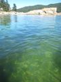
A calm place to rest after crossing choppy Coles Bay.
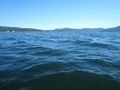
One of about 4 pictures snapped as I drifted through the Geohash coordinate.
Cropped and color-modified picture of above showing I made the coordinates.
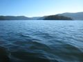
Looking south from the Geohash location.
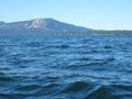
Looking north from the Geohash location (the barren hill is on Saltspring Island).
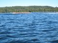
Senanus Island to my right as I paddled back.
The local tribe appeared to be holding war canoe races.
The Mill Bay Ferry heading out again.
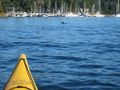
A seal bobbing just outside Brentwood Bay; all I managed to capture was the back of his head.
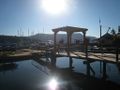
Relaxing afterwards at the Seahorses Cafe.
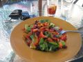
Reward for my efforts!


Achievements
Wenslayer earned the Water geohash achievement
|