Difference between revisions of "2010-09-14 -36 174"
From Geohashing
imported>Greenslime m (→Photos) |
imported>Greenslime m |
||
| Line 36: | Line 36: | ||
<!-- Add any achievement ribbons you earned below, or remove this section --> | <!-- Add any achievement ribbons you earned below, or remove this section --> | ||
| − | |||
| − | |||
| − | |||
| − | |||
| − | |||
| − | |||
[[Category:Expeditions]] | [[Category:Expeditions]] | ||
| − | |||
[[Category:Expeditions with photos]] | [[Category:Expeditions with photos]] | ||
| − | |||
[[Category:Expedition without GPS]] | [[Category:Expedition without GPS]] | ||
| − | |||
| − | |||
| − | |||
[[Category:Coordinates reached]] | [[Category:Coordinates reached]] | ||
| − | |||
| − | |||
| − | |||
| − | |||
| − | |||
| − | |||
| − | |||
| − | |||
| − | |||
| − | |||
Revision as of 05:44, 14 September 2010
| Tue 14 Sep 2010 in -36,174: -36.8685115, 174.9063948 geohashing.info google osm bing/os kml crox |
Location
A house in Bucklands Beach, Auckland - 143 Clovelly Road
Participants
Plans
Drive there, after work, take running gear and run up the peninsula.
Expedition
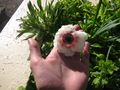
Yeah, not that exciting, drive there, take photo. The highlight was the view on the 7 km run from the hash point up to the tip of the peninsula (Musick Point) and back... and the flowers which remind me that spring is approaching!
Tracklog
Photos
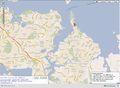
Surprised this landed on land!
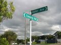
Street signs as evidence that this is in fact 143 Clovelley, and not some other 143.
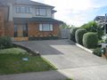
143 Clovelley, hash is in their back yard
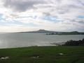
View of Rangitoto Island from Musick Point peninsula
Reminder of spring


