Difference between revisions of "2010-10-10 59 22"
imported>Jusu |
imported>Jusu (→Photos) |
||
| Line 37: | Line 37: | ||
<!-- == Tracklog == --> | <!-- == Tracklog == --> | ||
== Photos == | == Photos == | ||
| − | |||
| − | |||
| − | |||
| − | |||
<gallery perrow="5"> | <gallery perrow="5"> | ||
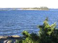
| + | Image:2010-10-10 59 22 From west 100m IMG 2140.jpg | 100 m to hash | ||
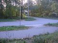
| + | Image:2010-10-10 59 22 Hashpoint1 IMG 2141.jpg | The hashpoint | ||
| + | Image:2010-10-10 59 22 Hashpoint2 IMG 2157.jpg | View towards Purjeentekijänkatu (Sailmaker's road) | ||
| + | Image:2010-10-10 59 22 Hashpoint3 IMG 2168.jpg | View towards Köydenpunojankatu (Ropemaker's road). Do you think it is annoying when I translate all names? :) | ||
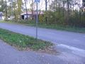
| + | Image:2010-10-10 59 22 Marker set IMG 2167.jpg | Marker set | ||
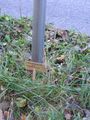
| + | Image:2010-10-10 59 22 Marker close-up IMG 2138.jpg | Marker | ||
| + | Image:2010-10-10 59 22 Pingviini IMG 2139.jpg | Marker documented properly. Six Penguin chocolate cones. Ice cream, you know. | ||
| + | Image:2010-10-10 59 22 GPS IMG 2155.jpg | Coordinates, time and date. Again difficult to get a decent photo from the screen. | ||
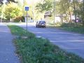
| + | Image:2010-10-10 59 22 Rock near hash IMG 2162.jpg | A rock next to the hash | ||
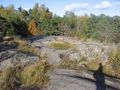
| + | Image:2010-10-10 59 22 Luulosaari GC IMG 2172.jpg | Totally unrelated photo. View near a [http://coord.info/GC2DPCX geocache] which I visited after the hash. | ||
</gallery> | </gallery> | ||
Revision as of 13:27, 11 October 2010
| Sun 10 Oct 2010 in Hanko, Finland: 59.8328899, 22.9365460 geohashing.info google osm bing/os kml crox |
Location
Hangonkylä, Hanko. Topo map. On the street Kappelisatamantie (Chapel Harbour's Road). Hashpoint is about 3 kilometers from the southernmost tip of continental Finland.
Participants
Plans
Drive there after swimming and having lunch. Distance from home is about 42 km, maybe 70 km by road. Probably won't make it before 3:00 PM. Then visit some geocaches.
Expedition
Still under construction, I guess...
Phone's navigator showed 65 km distance from home. I passed the hashpoint at 4:00 PM. Then drove back and forth few times before deciding to park 120 m west by houses.
The point was on a street in residential area of detached houses. Hashpoint was well visible only from one house. There were trees and bushes on both sides of the street. A path led from the hashpoint to a rock on the north side of the street. There I found a triangulation point's benchmark bolt on 14.3 m altitude. You can see that in the topo map. Height of the hashpoint was 4-5 m above sea level. This time I also left a marker.
Temperature was about +10°C. Sun was shining brightly. Gale wind from the north made the weather quite chilly.
Check Hanko in wikipedia. It's a nice little town with sandy beaches, old wooden houses and interesting wartime history. There's more life in the summertime than now.
Photos
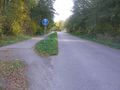
100 m to hash
The hashpoint
View towards Purjeentekijänkatu (Sailmaker's road)
View towards Köydenpunojankatu (Ropemaker's road). Do you think it is annoying when I translate all names? :)
Marker set

Marker
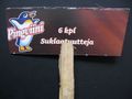
Marker documented properly. Six Penguin chocolate cones. Ice cream, you know.
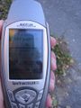
Coordinates, time and date. Again difficult to get a decent photo from the screen.
A rock next to the hash
Totally unrelated photo. View near a geocache which I visited after the hash.


Achievements
Jusu achieved level 3 of the Minesweeper Geohash achievement
|
