Difference between revisions of "2010-10-12 29 -95"
imported>Phineas (→Photos) |
imported>Phineas (→Achievements) |
||
| Line 58: | Line 58: | ||
{{#vardefine:ribbonwidth|800px}} | {{#vardefine:ribbonwidth|800px}} | ||
<!-- Add any achievement ribbons you earned below, or remove this section --> | <!-- Add any achievement ribbons you earned below, or remove this section --> | ||
| + | |||
| + | {{Speed racer | ||
| + | |||
| + | | latitude = 29 | ||
| + | | longitude = -95 | ||
| + | | date = date 2010-10-12 | ||
| + | | name = [[User:phineas|Phineas]] | ||
| + | | speed = 40 mph | ||
| + | }} | ||
| + | |||
| + | [[Category:Expeditions]] | ||
| + | [[Category:Coordinates reached]] | ||
| + | [[Category:Expeditions]] | ||
| + | [[Category:Expeditions with photos]] | ||
Revision as of 21:01, 18 October 2010
| Tue 12 Oct 2010 in 29,-95: 29.7547253, -95.3980618 geohashing.info google osm bing/os kml crox |
Location
On Waugh St. between Clay and W. Gray Sts., west of downtown Houston. Arty / emerging area. Not sure what's on this block - can't wait to learn. Could be a boutique, ice-house, auto shop, or as is so likely in Houston, a nail salon.
Participants
Plans
1:30 PM CDT - speed racer drive through - then return to wander around and snap photos - if the neighborhood is not a dangerous hood.
Expedition
Successful!!
A quick jaunt from downtown Houston west to this haspoint. Even though I could find the intersection without a GPS, I wanted to catch the lat/long on the device. But, I fumble fingered one digit in the lat, and the GPS keep giving me bad directions - which I ignored until after I arrived.
Nice little neighborhood, beautiful sunny day. Reach the hash via a few roads I'd never been on - nice to see different surroundings in an area I thought I knew already.
GPS photo is from across the street from point, after Speed Racing through.
All the elements of a pleasant, quick urban Geohash.
Tracklog
Photos
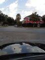
Quaint neighborhood surrounds hashpoint. Note the palm trees
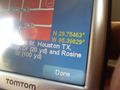
Finally a clear GPS picture - across the intersection from hash
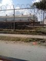
A pleasant view a few blocks away. Yikes.


Achievements
Phineas earned the Speed racer achievement
|