Difference between revisions of "2011-07-24 47 7"
From Geohashing
imported>Hijackal (doesn't need much planning for me...) |
imported>Hijackal (two pics, more soon.) |
||
| Line 26: | Line 26: | ||
== Expedition == | == Expedition == | ||
| − | + | Soon. | |
| − | |||
| − | |||
| − | |||
== Photos == | == Photos == | ||
| Line 36: | Line 33: | ||
--> | --> | ||
<gallery perrow="5"> | <gallery perrow="5"> | ||
| + | Image:2011-07-24 47 7 hashmap.png | The hash! | ||
| + | Image:2011-07-24_47_7_apricots_ring.png | The strange and mysterious ritual of the ring and the apricots | ||
</gallery> | </gallery> | ||
== Achievements == | == Achievements == | ||
{{#vardefine:ribbonwidth|800px}} | {{#vardefine:ribbonwidth|800px}} | ||
| − | |||
| − | |||
| − | |||
| − | |||
| − | |||
| − | |||
| − | |||
| − | |||
| − | [[ | + | {{Hobbit achievement |
| + | | latitude = 47 | ||
| + | | longitude = 7 | ||
| + | | date = 2011-07-24 | ||
| + | | pronoun = his | ||
| + | | name = [[User:Hijackal|Hijackal]] | ||
| + | | image = 2011-07-24_47_7_apricots_ring.png | ||
| + | }} | ||
| + | {{No_batteries_geohash | ||
| + | | latitude = 47 | ||
| + | | longitude = 7 | ||
| + | | date = 2011-07-24 | ||
| + | | name = [[User:Hijackal|Hijackal]] | ||
| + | | image = 2011-07-24 47 7 hashmap.png | ||
| + | }} | ||
| − | |||
[[Category:Expeditions]] | [[Category:Expeditions]] | ||
| − | |||
[[Category:Expeditions with photos]] | [[Category:Expeditions with photos]] | ||
| − | + | ||
| − | |||
| − | |||
| − | |||
| − | |||
[[Category:Coordinates reached]] | [[Category:Coordinates reached]] | ||
| − | |||
| − | |||
| − | |||
| − | |||
| − | |||
| − | |||
| − | |||
| − | |||
| − | |||
| − | |||
Revision as of 19:14, 24 July 2011
| Sun 24 Jul 2011 in 47,7: 47.9434130, 7.9556049 geohashing.info google osm bing/os kml crox |
Location
In a corn (?) field 2 km south of Kirchzarten, about 10 km from Freiburg.
Participants
Plans
Hijackal will probably walk there. Maybe barefoot... If anyone wants to suggest a time, he might even bring a game.
Expedition
Soon.
Photos
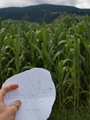
The hash!
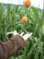
The strange and mysterious ritual of the ring and the apricots


Achievements
Hijackal earned the Hobbit Achievement
|
Hijackal earned the No Batteries Geohash Achievement
|