Difference between revisions of "2011-12-05 -39 175"
imported>Greenslime m |
imported>Greenslime m (+ 1 failed hash - but still loves native NZ bush =)) |
||
| Line 1: | Line 1: | ||
| − | |||
| − | |||
| − | |||
| − | |||
| − | |||
| − | |||
| − | |||
| − | |||
| − | |||
{{meetup graticule | {{meetup graticule | ||
| lat=-39 | | lat=-39 | ||
| Line 14: | Line 5: | ||
}} | }} | ||
| − | + | ||
__NOTOC__ | __NOTOC__ | ||
== Location == | == Location == | ||
| − | Beside a railway track, Erua, Central Plateau, | + | Beside a railway track, Erua, Central Plateau, New Zealand |
== Participants == | == Participants == | ||
| − | Greenslime | + | [[User:Greenslime|Greenslime]] |
| + | |||
== Plans == | == Plans == | ||
| − | + | Currently at an internet cafe and rapidly running out of credit looking at maps. This hash is close to my current location and so very close to a track I have been reconnoitering up Mt Hauhungatahi (1521 m, Old Baldy!) Coincidence? I think not! | |
| − | |||
== Expedition == | == Expedition == | ||
| − | + | All I can say is its 171 m that way... (points...) Feeling rather disheartened just looking at the extrapolated hash location, I stepped over the train-track and ventured a mere 10 m inwards to find a water filled channel running parallel to the train-tracks. Literally already in over my head in thick New Zealand native bush, I gave up...but it looked so easy on the map (sulk). | |
| − | |||
| − | |||
| − | |||
== Photos == | == Photos == | ||
| − | |||
| − | |||
| − | |||
<gallery perrow="5"> | <gallery perrow="5"> | ||
| + | File:2011-12-05 -39 175 171m That Way.jpg|Its 171 m that way (points...) a spur to Old Baldy in the background | ||
| + | File:2011-12-05 -39 175 Old Baldy.JPG|600 m between hash (upper) and trail head to Old Baldy (lower) | ||
| + | File:2011-12-05 -39 175 Erua.jpg|Erua, a very very very small settlement in the Central Plateau | ||
</gallery> | </gallery> | ||
== Achievements == | == Achievements == | ||
{{#vardefine:ribbonwidth|800px}} | {{#vardefine:ribbonwidth|800px}} | ||
| − | + | {{mnb geohash | |
| − | + | | latitude = -39 | |
| + | | longitude = 175 | ||
| + | | date = 2011-12-05 | ||
| + | | name = [[User:Greenslime|Greenslime]] | ||
| + | | image = 2011-12-05 -39 175 171m That Way.jpg | ||
| + | }} | ||
| − | |||
| − | |||
[[Category:Expeditions]] | [[Category:Expeditions]] | ||
| − | |||
[[Category:Expeditions with photos]] | [[Category:Expeditions with photos]] | ||
| − | |||
| − | |||
| − | |||
| − | |||
| − | |||
| − | |||
| − | |||
| − | |||
| − | |||
[[Category:Coordinates not reached]] | [[Category:Coordinates not reached]] | ||
| − | + | [[Category:Not reached - Mother Nature]] | |
| − | [[Category:Not reached - Mother Nature]] | ||
| − | |||
| − | |||
| − | |||
| − | |||
Revision as of 03:24, 5 December 2011
| Mon 5 Dec 2011 in -39,175: -39.2262590, 175.4006399 geohashing.info google osm bing/os kml crox |
Location
Beside a railway track, Erua, Central Plateau, New Zealand
Participants
Plans
Currently at an internet cafe and rapidly running out of credit looking at maps. This hash is close to my current location and so very close to a track I have been reconnoitering up Mt Hauhungatahi (1521 m, Old Baldy!) Coincidence? I think not!
Expedition
All I can say is its 171 m that way... (points...) Feeling rather disheartened just looking at the extrapolated hash location, I stepped over the train-track and ventured a mere 10 m inwards to find a water filled channel running parallel to the train-tracks. Literally already in over my head in thick New Zealand native bush, I gave up...but it looked so easy on the map (sulk).
Photos
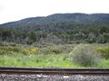
Its 171 m that way (points...) a spur to Old Baldy in the background
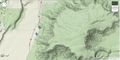
600 m between hash (upper) and trail head to Old Baldy (lower)
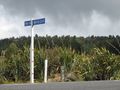
Erua, a very very very small settlement in the Central Plateau


