Difference between revisions of "2008-05-24 54 -2"
From Geohashing
imported>FippeBot m (Location) |
m (Replacing Peeron with Geohashing.info) |
||
| Line 7: | Line 7: | ||
==About== | ==About== | ||
| − | On [[2008-05-24|24th May 2008]], the first Saturday meeting since the algorithm was published, the geohash for [[Carlisle, United Kingdom|Carlisle]] was a field of cows near Low Bentham, North Yorkshire at | + | On [[2008-05-24|24th May 2008]], the first Saturday meeting since the algorithm was published, the geohash for [[Carlisle, United Kingdom|Carlisle]] was a field of cows near Low Bentham, North Yorkshire at {{egl|2008-05-24|54,-2|text=54.126648°, -2.547534°}}. |
Two separate groups from Lancaster met on the path to the field and got as close as possible without wanting to disturb the cows. A family from Kendal reached the actual co-ordinates with a compass and no GPS. All three groups enjoyed a round of drinks afterwards at a local pub - mission successful! | Two separate groups from Lancaster met on the path to the field and got as close as possible without wanting to disturb the cows. A family from Kendal reached the actual co-ordinates with a compass and no GPS. All three groups enjoyed a round of drinks afterwards at a local pub - mission successful! | ||
Revision as of 20:29, 15 January 2022
| Sat 24 May 2008 in 54,-2: 54.1266480, -2.5475331 geohashing.info google osm bing/os kml crox |
About
On 24th May 2008, the first Saturday meeting since the algorithm was published, the geohash for Carlisle was a field of cows near Low Bentham, North Yorkshire at 54.126648°, -2.547534°.
Two separate groups from Lancaster met on the path to the field and got as close as possible without wanting to disturb the cows. A family from Kendal reached the actual co-ordinates with a compass and no GPS. All three groups enjoyed a round of drinks afterwards at a local pub - mission successful!
People
- Nick Taylor
- Bramp and Nic
- C and K (and C's family) representing the Chronos Empire
Photos
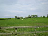
A field containing coordinates and cows.
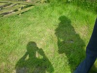
More than one person!

The actual spot (probably)


