Difference between revisions of "2012-08-09 52 0"
From Geohashing
imported>Sourcerer ([live] Not reached about one hour ago due to a pig farm field.) |
imported>Sourcerer |
||
| Line 1: | Line 1: | ||
| − | |||
| − | |||
| − | |||
| − | |||
| − | |||
| − | |||
| − | |||
| − | |||
| − | |||
| − | |||
{{meetup graticule | {{meetup graticule | ||
| − | | lat=52 | + | | lat=52 |
| − | | lon=0 | + | | lon=0 |
| − | | date=2012-08-09 | + | | date=2012-08-09 |
| + | | graticule_name=Cambridge | ||
| + | | graticule_link=Cambridge, United Kingdom | ||
}} | }} | ||
| − | |||
| − | |||
== Location == | == Location == | ||
| − | + | ||
| + | [[User:Sourcerer|Sourcerer]] failed to reach the hashpoint in a very muddy pig field. | ||
== Participants == | == Participants == | ||
| − | |||
| − | |||
| − | + | [[User:Sourcerer|Sourcerer]] | |
| − | |||
| − | == Expedition == | + | == Expedition - Failed == |
| − | |||
| + | *Not reached about one hour ago due to a pig farm field. -- [[User:Sourcerer|Sourcerer]] [http://www.openstreetmap.org/?lat=52.312511801719666&lon=-0.690963864326477&zoom=16&layers=B000FTF @52.3125,-.6910] 11:35, 09 August 2012 (GMT+01:00) | ||
| − | + | Neil was on his way to a wedding in Scotland. This was attempt 1 of 5 on this day. | |
| − | |||
| − | |||
== Photos == | == Photos == | ||
| − | + | ||
| − | |||
| − | |||
<gallery perrow="5"> | <gallery perrow="5"> | ||
| + | Image:2012-08-09 52 0 Sourcerer 1.jpg|Google Earth track | ||
| + | Image:2012-08-09 52 0 Sourcerer 2.jpg|The Muddy Farm | ||
</gallery> | </gallery> | ||
| − | == | + | == Other geohashing expeditions on the same day == |
| − | |||
| − | |||
| − | |||
| − | |||
| − | |||
| − | |||
| − | |||
| − | + | {{expedition summaries|2012-08-09}} | |
| − | |||
| − | |||
| − | |||
| − | |||
[[Category:Expeditions]] | [[Category:Expeditions]] | ||
| − | |||
[[Category:Expeditions with photos]] | [[Category:Expeditions with photos]] | ||
| − | |||
| − | |||
| − | |||
| − | |||
| − | |||
| − | |||
| − | |||
| − | |||
| − | |||
[[Category:Coordinates not reached]] | [[Category:Coordinates not reached]] | ||
| − | |||
| − | |||
| − | |||
| − | |||
| − | |||
| − | |||
| − | |||
| − | |||
| − | |||
| − | |||
| − | |||
| − | |||
| − | |||
| − | |||
Revision as of 14:47, 10 August 2012
| Thu 9 Aug 2012 in Cambridge: 52.3125551, 0.6909587 geohashing.info google osm bing/os kml crox |
Contents
Location
Sourcerer failed to reach the hashpoint in a very muddy pig field.
Participants
Expedition - Failed
- Not reached about one hour ago due to a pig farm field. -- Sourcerer @52.3125,-.6910 11:35, 09 August 2012 (GMT+01:00)
Neil was on his way to a wedding in Scotland. This was attempt 1 of 5 on this day.
Photos
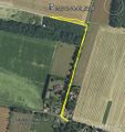
Google Earth track
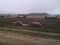
The Muddy Farm


Other geohashing expeditions on the same day
Expeditions and Plans
| 2012-08-09 | ||
|---|---|---|
| Atlanta, Georgia | NWoodruff | In a well over grown lot in Vinings. |
| Youngstown, Ohio | User:Fezzic181 | Found the spot out in the middle of the state game lands. |
| Billings, Montana | Rory | Lake Elmo State Park north of Billings, MT. The actual hash point is in th... |
| Northampton, United Kingdom | Sourcerer | 2) On an urban public path through attractive lawns and trees in Wellingbor... |
| Birmingham, United Kingdom | Sourcerer | 3) A few metres off a public footpath in a hay field. This was near the Gra... |
| Cambridge, United Kingdom | Sourcerer | 1) Sourcerer failed to reach the hashpoint in a very muddy pig field. |
| Amsterdam, Netherlands | Marvyn | Behind a container-like building in some shrubs in an urban area in Hoofddo... |
| Manchester, United Kingdom | Sourcerer | 4) Close to junction 12 on the M56. The hashpoint was on or very close to t... |
| Dundee, United Kingdom | Sourcerer | 5) Beside the coast road east of St. Andrews, Fife, Scotland, UK. |