Difference between revisions of "2012-12-23 29 -81"
imported>Grumpa |
imported>Jiml m (Add ribbon, result codes) |
||
| Line 14: | Line 14: | ||
}} | }} | ||
| − | + | ||
__NOTOC__ | __NOTOC__ | ||
== Location == | == Location == | ||
| Line 20: | Line 20: | ||
== Participants == | == Participants == | ||
| − | [[User:Grumpa|Grumpa]] | + | * [[User:Grumpa|Grumpa]] |
== Plans == | == Plans == | ||
| Line 28: | Line 28: | ||
After picking up the achievement in the Gainesville graticule (I hoped) I headed east to try and find the one in the Dayton Beach graticule. The one would be a bit more difficult as there weren't as many east to stop landmarks nearby. | After picking up the achievement in the Gainesville graticule (I hoped) I headed east to try and find the one in the Dayton Beach graticule. The one would be a bit more difficult as there weren't as many east to stop landmarks nearby. | ||
| − | Up until this point I was, for the most part, the only one in the sky around me. That changed markedly as I | + | Up until this point I was, for the most part, the only one in the sky around me. That changed markedly as I approached Palatka. Not only did half a dozen other pilots think it was a great day to fly but the Palatka airport is a very active skydiving location. I had planned on making a touch-and-go both comimg and going but decided against it. Five airplanes running around the pattern (at least two of which were piloted by English-as-a-second-language pilots) plus bodies falling from 13,500' all at an untowered airport said one thing to me...STAY CLEAR. Note I am not making any judgement on the skills of the multi-lingual pilots. But listening to the efforts of the skydiver's pilot in trying to get everyone else to understand what he was doing and when was...interesting. No point in adding myself to the mix. |
Anyway, I skirted around to the north of the airport then headed south to the hash point. Luckily the tree pattern on the ground wasn't that different from what I saw on Google Earth and I was able to make a couple of reasonable passes. Not as close as the first time (as I found out later) but still within the required accuracy. | Anyway, I skirted around to the north of the airport then headed south to the hash point. Luckily the tree pattern on the ground wasn't that different from what I saw on Google Earth and I was able to make a couple of reasonable passes. Not as close as the first time (as I found out later) but still within the required accuracy. | ||
| − | On the way back I went on the south side of the Palatka airport then made | + | On the way back I went on the south side of the Palatka airport then made straight to Gainesville. I still had time left on the rental but I had spent enough money for one day. If I had put that money instead in my car I could have bought enough to gas to drive to Chicago and back collecting who knows how many hash points. But as anyone who flies knows...if you start thinking about what you could have bought instead of flying...you'd never fly. |
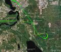
For anyone looking at the overall flightpath (the last picture) and wondering why I didn't go straight from one hashpoint to the other, there's a large Military Operations Area south of Palatka including a Restricted area. Yes, there are ways to fly through them but overall it is just easier to go around. | For anyone looking at the overall flightpath (the last picture) and wondering why I didn't go straight from one hashpoint to the other, there's a large Military Operations Area south of Palatka including a Restricted area. Yes, there are ways to fly through them but overall it is just easier to go around. | ||
| Line 52: | Line 52: | ||
{{Multihash | latitude1 = 29 | longitude1 = -82 | latitude2 = 29 | longitude2 = -81 | date = 2012-12-23 | name = Grumpa }} | {{Multihash | latitude1 = 29 | longitude1 = -82 | latitude2 = 29 | longitude2 = -81 | date = 2012-12-23 | name = Grumpa }} | ||
| + | {{Air geohash | latitude = 29 | longitude = -81 | date = 2012-12-23 | name = Grumpa }} | ||
| − | |||
| − | |||
| − | |||
| − | |||
| − | |||
| − | |||
| − | |||
| − | |||
[[Category:Expeditions]] | [[Category:Expeditions]] | ||
| − | + | ||
[[Category:Expeditions with photos]] | [[Category:Expeditions with photos]] | ||
| − | |||
| − | |||
| − | |||
| − | |||
| − | |||
[[Category:Coordinates reached]] | [[Category:Coordinates reached]] | ||
| − | |||
| − | |||
| − | |||
| − | |||
| − | |||
| − | |||
| − | |||
| − | |||
| − | |||
| − | |||
| − | |||
| − | |||
| − | |||
| − | |||
| − | |||
| − | |||
| − | |||
| − | |||
Revision as of 12:35, 25 December 2012
| Sun 23 Dec 2012 in 29,-81: 29.5585921, -81.5100048 geohashing.info google osm bing/os kml crox |
Location
Forested area seoutheast of Palatka, Florida.
Participants
Plans
Fly over the hash point in an effort to earn the multihash achievement.
Expedition
After picking up the achievement in the Gainesville graticule (I hoped) I headed east to try and find the one in the Dayton Beach graticule. The one would be a bit more difficult as there weren't as many east to stop landmarks nearby.
Up until this point I was, for the most part, the only one in the sky around me. That changed markedly as I approached Palatka. Not only did half a dozen other pilots think it was a great day to fly but the Palatka airport is a very active skydiving location. I had planned on making a touch-and-go both comimg and going but decided against it. Five airplanes running around the pattern (at least two of which were piloted by English-as-a-second-language pilots) plus bodies falling from 13,500' all at an untowered airport said one thing to me...STAY CLEAR. Note I am not making any judgement on the skills of the multi-lingual pilots. But listening to the efforts of the skydiver's pilot in trying to get everyone else to understand what he was doing and when was...interesting. No point in adding myself to the mix.
Anyway, I skirted around to the north of the airport then headed south to the hash point. Luckily the tree pattern on the ground wasn't that different from what I saw on Google Earth and I was able to make a couple of reasonable passes. Not as close as the first time (as I found out later) but still within the required accuracy.
On the way back I went on the south side of the Palatka airport then made straight to Gainesville. I still had time left on the rental but I had spent enough money for one day. If I had put that money instead in my car I could have bought enough to gas to drive to Chicago and back collecting who knows how many hash points. But as anyone who flies knows...if you start thinking about what you could have bought instead of flying...you'd never fly.
For anyone looking at the overall flightpath (the last picture) and wondering why I didn't go straight from one hashpoint to the other, there's a large Military Operations Area south of Palatka including a Restricted area. Yes, there are ways to fly through them but overall it is just easier to go around.
Photos
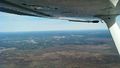
Descending from the previous Mile High award, looking north over Gainesville, Florida
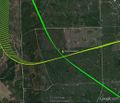
My two passes over the hash point in the Daytone Beach graticule
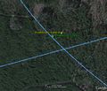
Close-up of the first pass. I'm about 145' away.
My flight path in the area
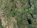
My entire path for the day. 1.6 hours on the Hobbs meter.


Achievements
Grumpa earned the Multihash Achievement
|
Grumpa earned the Air geohash achievement
|