Difference between revisions of "2013-02-26 48 11"
imported>Zertrin (coords reached, full report come later) |
imported>Zertrin (fill report) |
||
| Line 1: | Line 1: | ||
| − | |||
| − | |||
| − | |||
| − | |||
| − | |||
| − | |||
| − | |||
| − | |||
| − | |||
| − | |||
{{meetup graticule | {{meetup graticule | ||
| lat=48 | | lat=48 | ||
| Line 14: | Line 4: | ||
| date=2013-02-26 | | date=2013-02-26 | ||
}} | }} | ||
| − | |||
| − | |||
__NOTOC__ | __NOTOC__ | ||
== Location == | == Location == | ||
| Line 28: | Line 16: | ||
== Expedition == | == Expedition == | ||
| − | + | [[2013-01-12 48 11|Once]] [[2013-01-13 48 12|again]], 26th and 27th of February provided a great opportunity of achieving Midnight Double Geohashes, the two hashes being only 10 km away from each other. | |
| + | |||
| + | We decided not to let the month of February have a score of zero for Munich's graticule and thus to attempt both of these hashes. | ||
| + | |||
| + | We departed at a bit after 11 p.m. toward the first hash. We found a little parking along the road 471 not too far away from the access to the bike path. This one was quite an easy one as it was located right next to the bike path along the Isar river. However, due to the regular snowfalls in Munich this winter, we still had to deal with a thick cover of snow in which we easily sank by 15 to 20 centimeters. | ||
| + | |||
| + | After reaching the hashpoint, taking the usual pictures (included some long exposure pictures to transform the night into daytime), we headed back to the car in order to attempt the [[2013-02-27 48 11|next geohash]] on the next day. | ||
== Tracklog == | == Tracklog == | ||
| Line 34: | Line 28: | ||
== Photos == | == Photos == | ||
| − | |||
| − | |||
| − | |||
| − | |||
<gallery perrow="5"> | <gallery perrow="5"> | ||
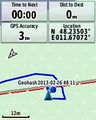
| + | Image:2013-02-26 48 11 Zertrin - GPS coords.jpg | Coordinates reached :) | ||
| + | Image:2013-02-26 48 11 Zertrin - Date and coordinates.JPG | Date and coordinates | ||
| + | Image:2013-02-26 48 11 Zertrin - vermouthandgin and Zertrin at hashpoint.JPG | [[User:vermouthandgin|vermouthandgin]] and [[User:Zertrin|Zertrin]] at the hashpoint | ||
| + | Image:2013-02-26 48 11 Zertrin - Day in the night.JPG | With 20 seconds of exposure, even dark night looks like daytime :) | ||
</gallery> | </gallery> | ||
| Line 44: | Line 38: | ||
{{#vardefine:ribbonwidth|800px}} | {{#vardefine:ribbonwidth|800px}} | ||
<!-- Add any achievement ribbons you earned below, or remove this section --> | <!-- Add any achievement ribbons you earned below, or remove this section --> | ||
| − | + | {{consecutive geohash | count = 3 | latitude = 48 | longitude = 11 | date = 2013-02-26 | name = [[User:Zertrin|Zertrin]] and [[User:Vermouthandgin|vermouthandgin]] }} | |
| + | {{Midnight geohash | latitude = 48 | longitude = 11 | date = 2013-02-26 | name = [[User:Zertrin|Zertrin]] and [[User:Vermouthandgin|vermouthandgin]] | image = 2013-02-26 48 11 Zertrin - Date and coordinates.JPG }} | ||
[[Category:Expeditions]] | [[Category:Expeditions]] | ||
[[Category:Expeditions with photos]] | [[Category:Expeditions with photos]] | ||
[[Category:Coordinates reached]] | [[Category:Coordinates reached]] | ||
Revision as of 23:53, 28 February 2013
| Tue 26 Feb 2013 in 48,11: 48.2350292, 11.6707214 geohashing.info google osm bing/os kml crox |
Location
Next to the path along the Isar river, near Ismaning, NE of München.
Participants
Plans
Reach the Midnight double.
Expedition
Once again, 26th and 27th of February provided a great opportunity of achieving Midnight Double Geohashes, the two hashes being only 10 km away from each other.
We decided not to let the month of February have a score of zero for Munich's graticule and thus to attempt both of these hashes.
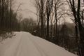
We departed at a bit after 11 p.m. toward the first hash. We found a little parking along the road 471 not too far away from the access to the bike path. This one was quite an easy one as it was located right next to the bike path along the Isar river. However, due to the regular snowfalls in Munich this winter, we still had to deal with a thick cover of snow in which we easily sank by 15 to 20 centimeters.
After reaching the hashpoint, taking the usual pictures (included some long exposure pictures to transform the night into daytime), we headed back to the car in order to attempt the next geohash on the next day.
Tracklog
Photos
Coordinates reached :)

Date and coordinates
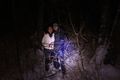
vermouthandgin and Zertrin at the hashpoint
With 20 seconds of exposure, even dark night looks like daytime :)


Achievements
Zertrin and vermouthandgin earned the Consecutive geohash achievement
|
Zertrin and vermouthandgin earned the Midnight Geohash achievement
|