Difference between revisions of "2013-04-14 52 1"
From Geohashing
imported>Sourcerer m ([live] Arrived.) |
imported>Sourcerer (→New expedition by Sourcerer) |
||
| Line 1: | Line 1: | ||
| − | |||
| − | |||
| − | |||
| − | |||
| − | |||
| − | |||
| − | |||
| − | |||
| − | |||
| − | |||
{{meetup graticule | {{meetup graticule | ||
| lat=52 | | lat=52 | ||
| Line 15: | Line 5: | ||
}} | }} | ||
| − | |||
| − | |||
== Location == | == Location == | ||
| − | + | In a wheat field between the A12 and the coast north of Lowestoft, Suffolk, UK. | |
== Participants == | == Participants == | ||
| − | + | [[User:Sourcerer|Sourcerer]] | |
| − | |||
| − | |||
| − | |||
| − | |||
== Expedition == | == Expedition == | ||
| − | + | *Arrived. -- [[User:Sourcerer|Sourcerer]] ([[User talk:Sourcerer|talk]]) [http://www.openstreetmap.org/?lat=52.524009346961975&lon=1.7272353172302246&zoom=16&layers=B000FTF @52.5240,1.7272] 18:34, 14 April 2013 (GMT+01:00) | |
| − | |||
| − | + | This was success four of five attempts today. After a weekend of beer and curry with good friends, the journey home crossed five graticules. The winter weather had finally given way to April sun with gusty winds but it was much warmer and pleasant to be out and about. There was a convenient lay by close to the hashpoint so parking the car was easy. The wheat field could be reached easily and tractor tracks were used to reach the hashpoint without treading on the seedlings. | |
| − | |||
| − | |||
== Photos == | == Photos == | ||
| − | < | + | <gallery perrow="4"> |
| − | Image: | + | Image:2013-04-14 52 1 Sourcerer 1.jpg | The Hashpoin |
| − | -- | + | Image:2013-04-14_52 1 Sourcerer 2.jpg | Tracklog |
| − | |||
</gallery> | </gallery> | ||
== Achievements == | == Achievements == | ||
| − | |||
| − | |||
| + | {{Multihash2 | ||
| + | | count = 4 | ||
| + | | date = 2013-04-14 | ||
| + | | name = Sourcerer | ||
| + | }} | ||
| − | |||
| − | |||
| − | |||
| − | |||
| − | |||
| − | |||
| − | |||
| − | |||
| − | |||
| − | |||
[[Category:Expeditions]] | [[Category:Expeditions]] | ||
| − | |||
[[Category:Expeditions with photos]] | [[Category:Expeditions with photos]] | ||
| − | |||
| − | |||
| − | |||
| − | |||
| − | |||
[[Category:Coordinates reached]] | [[Category:Coordinates reached]] | ||
| − | |||
| − | |||
| − | |||
| − | |||
| − | |||
| − | |||
| − | |||
| − | |||
| − | |||
| − | |||
| − | |||
| − | |||
| − | |||
| − | |||
| − | |||
| − | |||
| − | |||
| − | |||
Revision as of 21:16, 14 April 2013
| Sun 14 Apr 2013 in 52,1: 52.5239406, 1.7271735 geohashing.info google osm bing/os kml crox |
Location
In a wheat field between the A12 and the coast north of Lowestoft, Suffolk, UK.
Participants
Expedition
- Arrived. -- Sourcerer (talk) @52.5240,1.7272 18:34, 14 April 2013 (GMT+01:00)
This was success four of five attempts today. After a weekend of beer and curry with good friends, the journey home crossed five graticules. The winter weather had finally given way to April sun with gusty winds but it was much warmer and pleasant to be out and about. There was a convenient lay by close to the hashpoint so parking the car was easy. The wheat field could be reached easily and tractor tracks were used to reach the hashpoint without treading on the seedlings.
Photos
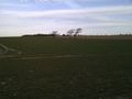
The Hashpoin
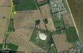
Tracklog


Achievements
Sourcerer earned the Multihash Achievement
|