Difference between revisions of "2014-01-16 47 -122"
imported>Thomcat (Details added, first success in Seattle in 2014) |
imported>FippeBot m (Location) |
||
| Line 35: | Line 35: | ||
[[Category:Expeditions with photos]] | [[Category:Expeditions with photos]] | ||
[[Category:Coordinates reached]] | [[Category:Coordinates reached]] | ||
| + | {{location|US|WA|SN}} | ||
Latest revision as of 05:15, 14 August 2019
| Thu 16 Jan 2014 in Seattle: 47.7930728, -122.0993223 geohashing.info google osm bing/os kml crox |
Location
East of the Maltby Cafe down Paradise Lake Road.
Participants
Plans
Stop by after work.
Expedition
Aerial image scouting reveals this to be a small fenced area off a main fenced pasture. Likely no livestock, possible access (as two of the four shots show an open gate). I couldn't make it before work, but decided to give it a go on the way home (well, 1-2 km out of my way - hardly worth the worry).
As I headed east, it got foggier in a very rapid fashion. I missed the turnoff - a one-lane non-paved roadish thing, despite what google maps and the car nav said. Went back and headed along to the junction. At that point I turned the car around to leave and parked. "We walk from here!"
I'll have to go back and look at the scale - the side yard containing the geohash point was only 8 feet across and maybe 10 deep. There was a gate hanging ajar; I opened it a bit further to go to the actual spot. Not a no-trespassing sign in sight for as far as the eye could see - which was maybe 50 yards in the fog.
Shoes slightly muddier, I returned to the car and drove out after waiting for another car to come along the one-lane road. They gave a cheery wave, which I returned. This is the way the world is supposed to work!
Photos
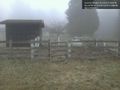
Spot pictured here @47.7931,-122.0993
