Difference between revisions of "2014-06-15 45 -122"
From Geohashing
imported>Michael5000 m (→Achievements) |
imported>Michael5000 (→Photos) |
||
| Line 36: | Line 36: | ||
== Photos == | == Photos == | ||
| − | + | ||
| − | |||
| − | |||
<gallery perrow="5"> | <gallery perrow="5"> | ||
| + | File:2014-06-16 45 -122 us.JPG|I remembered to grin, but not to keep my eyes open. | ||
| + | File:2014-06-16 45 -122 gadget.JPG|This is the place. | ||
| + | File:2014-06-16 45 -122 growl.JPG|Enjoying the lightly wooded landscape. | ||
| + | File:2014-06-16 45 -122 view.JPG|Looking down the hill at the nursing home. | ||
</gallery> | </gallery> | ||
Revision as of 01:16, 16 June 2014
| Sun 15 Jun 2014 in 45,-122: 45.8659918, -122.8243489 geohashing.info google osm bing/os kml crox |
Location
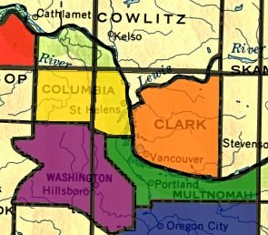
On a hillside just to the north of St. Helens, Oregon.
Participants
Plans
Expedition
Tracklog
Photos
Achievements
 This expedition takes care of the southeastern quarter of Columbia County on Michael5000's "stained glass" county-and-graticule map.


