Difference between revisions of "2014-10-01 51 11"
imported>TheOneRing (Created page with "{{meetup graticule | lat=51 | lon=11 | date=2014-10-01 }} == Location == The geohash is on a close to the campus of the University of Halle-Wittemberg. == Who Went == User...") |
imported>TheOneRing m |
||
| Line 6: | Line 6: | ||
== Location == | == Location == | ||
| − | The geohash is on a close to the campus of the University of Halle- | + | The geohash is on a close to the campus of the University of Halle-Wittenberg. |
== Who Went == | == Who Went == | ||
Revision as of 18:52, 19 October 2014
| Wed 1 Oct 2014 in 51,11: 51.4951713, 11.9319183 geohashing.info google osm bing/os kml crox |
Location
The geohash is on a close to the campus of the University of Halle-Wittenberg.
Who Went
TheOneRing - by foot.
The Expedition
I was at my parents' home for a week, and the campus is really close to them. So, I decided to achieve another walk geohash. The route was the same for the first 2km as at the tour of March 2012: over the Peissnitzinsel, along the painted model of the Solar system (this time I took some photographs), towards Halle-Neustadt.
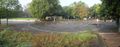
The buildings on campus were renovated or even newly built, so no comparison to the state when I was last time there, 13 to 14 years ago. Until 5 years ago, the institutes of the university were broadly distributed in Halle, so students had to go long ways to reach different institutes, which took also a lot of time. Now the institutes are closer together.
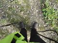
I crossed the campus towards a quarter of row housing. Just in front of the first row, there was the geohash. I took the usual photos and left a marker, bio-degradable. I had a lot of time, and walked a different (and much longer) way home.
Photos
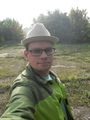
The hasher, or the Mad Hatter, as you wish
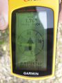
Coordinates reached
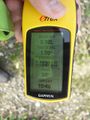
Some more information
Here I am
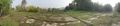
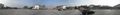
Panoramic view over the geohash area
The campus of the university
The model of the Solar system (inner planets)


Achievements
TheOneRing earned the Land geohash achievement
|
TheOneRing earned the Walk geohash Achievement
|