Difference between revisions of "2014-11-28 49 8"
From Geohashing
imported>Q-Owl |
imported>Q-Owl |
||
| Line 6: | Line 6: | ||
== Location == | == Location == | ||
Between [[wikipedia:Darmstadt|Darmstadt]] and DA-Eberstadt [[wikipedia:DA-Eberstadt|DA-Eberstadt]] on the cyclepath beside the federal highway B3 and the tramway track. | Between [[wikipedia:Darmstadt|Darmstadt]] and DA-Eberstadt [[wikipedia:DA-Eberstadt|DA-Eberstadt]] on the cyclepath beside the federal highway B3 and the tramway track. | ||
| + | |||
| + | Easy to reach by bicycle or public transport. | ||
== Participants == | == Participants == | ||
| Line 20: | Line 22: | ||
Version #1: Too tired. :-( | Version #1: Too tired. :-( | ||
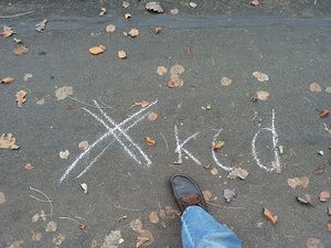
| − | Version #2: I reached the hashpoint area at 10:30, walked to the hashpoint, marked | + | Version #2: I reached the hashpoint area at 10:30, walked to the hashpoint, marked it with chalk, took some photos, smiled, looked for GC3030J, found it and drove back to work. |
== Photos == | == Photos == | ||
<gallery perrow="5" > | <gallery perrow="5" > | ||
| + | Image:2014-11-28 49 8 sc1.png | proof1 | ||
| + | Image:2014-11-28 49 8 sc2.png | proof2 | ||
Image:2014-11-28 49 8 mark.jpg | marked hashpoint | Image:2014-11-28 49 8 mark.jpg | marked hashpoint | ||
| + | Image:2014-11-28 49 8 n.jpg | view to N - to Darmstadt | ||
| + | Image:2014-11-28 49 8 w.jpg | view to W - the former US Lincoln Village | ||
| + | Image:2014-11-28 49 8 s.jpg | view to S - to DA Eberstadt | ||
| + | Image:2014-11-28 49 8 e.jpg | view to E - German jungle | ||
Image:2014-11-28 49 8 grin.jpg | smile | Image:2014-11-28 49 8 grin.jpg | smile | ||
</gallery> | </gallery> | ||
| − | |||
| − | |||
| − | |||
| − | |||
| − | |||
| − | |||
| − | |||
| − | |||
| − | |||
<!-- | <!-- | ||
List of uploaded Files: | List of uploaded Files: | ||
Revision as of 12:36, 28 November 2014
| Fri 28 Nov 2014 in 49,8: 49.8449873, 8.6461937 geohashing.info google osm bing/os kml crox |
Location
Between Darmstadt and DA-Eberstadt DA-Eberstadt on the cyclepath beside the federal highway B3 and the tramway track.
Easy to reach by bicycle or public transport.
Participants
Plan
Version #1: Reach the Cache at 00:00. :-)
Version #2: Take a break from work, drive by car near the hash area, walk to the hashpoint, take some photos, return to the car and drive to work. :-))
Nearest geocache: GC3030J about 450 m as a bird flies .
Expedition
Version #1: Too tired. :-(
Version #2: I reached the hashpoint area at 10:30, walked to the hashpoint, marked it with chalk, took some photos, smiled, looked for GC3030J, found it and drove back to work.
Photos
Achievements / Honorable Mention
Q-Owl earned the Land geohash achievement
|
Q-Owl earned the Birthday Geohash Achievement
|


