Difference between revisions of "2015-01-05 47 -118"
imported>Thomcat (Davenport expedition) |
imported>FippeBot m (Location) |
||
| Line 37: | Line 37: | ||
[[Category:Expeditions with photos]] | [[Category:Expeditions with photos]] | ||
[[Category:Coordinates reached]] | [[Category:Coordinates reached]] | ||
| + | {{location|US|WA|AD}} | ||
Latest revision as of 02:21, 15 August 2019
| Mon 5 Jan 2015 in Seattle: 47.1310418, -118.6527237 geohashing.info google osm bing/os kml crox |
Location
A farmer's field near I-90
Participants
Expedition
Another trip to Spokane, another chance to geohash. Left work early and stopped in George for a snap of the huge bronze bust of our first president. After that, I continued east to this geohash in the long-neglected Davenport graticule.
Found the road easily; most of the snow from the previous weekend had melted. Arriving just south of the geohash, I parked the car and surveyed the area. No cell signal, so screen capture would be the proof this time. In hindsight, it is a boring screen capture - first because there is no google map information (though I panned and zoomed in to it earlier - not in the cache?) and second because, even if there had been map information, it would have been a straight line road immediately 20 m. south of the hashpoint.
Anyhow, leading directly north from where I parked were twin parallel tracks. Too close together to be a car, I suspect some sort of utility vehicle or all-terrain vehicle (ATV). Taking advantage of those, I hiked into the field, which looked to be plowed under and ready for planting in the spring. I easily found the hashpoint, which looked pretty much like every other clod of dirt in the area. I saved a screenshot then took a 360 panarama - my car is immediately south in the picture.
Considered heading to the Colville graticule (virgin!) for a second geohash, but reconsidered upon arriving in Spokane to deeper snow, sunset and a dense fog. That plus a trip into the woods equals no geohash there today. Maybe tomorrow?!?
Photos

ATV tracks
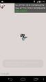
Screenshot proof

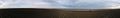
Panorama: car = south


