Difference between revisions of "2015-02-20 52 0"
From Geohashing
imported>Sourcerer m ([live] Arrived.) |
imported>Sourcerer m (→New Expedition) |
||
| Line 12: | Line 12: | ||
[[User:Sourcerer|Sourcerer]] | [[User:Sourcerer|Sourcerer]] | ||
| − | |||
| − | |||
| − | |||
| − | |||
== Expedition == | == Expedition == | ||
| + | *Arrived. -- [[User:Sourcerer|Sourcerer]] ([[User talk:Sourcerer|talk]]) [http://www.openstreetmap.org/?lat=52.95266390&lon=.83826542&zoom=16&layers=B000FTF @52.9527,.8383] 00:01, 20 February 2015 (GMT) | ||
| + | This was the second hashpoint of this excursion. It was raining. I arrived on the dot of midnight but dithered with the camera and took the photo at one minute past. There was a good place to park in a new road leading to new houses, nearing completion. The public footpath was slippery in the wet. There was a useful hole in the hedge and the hashpoint was in the muddy field. This looked like a harvested sugar beet field because there were tractor tracks everywhere. | ||
| − | |||
| − | |||
== Photos == | == Photos == | ||
<gallery perrow="5"> | <gallery perrow="5"> | ||
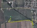
| + | Image:2015-02-20_52_0_Sourcerer_1.jpg | Proof | ||
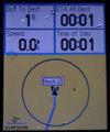
| + | Image:2015-02-20_52_0_Sourcerer_2.jpg | Track Log | ||
</gallery> | </gallery> | ||
== Achievements == | == Achievements == | ||
{{#vardefine:ribbonwidth|800px}} | {{#vardefine:ribbonwidth|800px}} | ||
| + | |||
| + | {{consecutive geohash 2 | ||
| + | | count = 6 | ||
| + | | latitude = 52 | ||
| + | | longitude = 1 | ||
| + | | date = 2015-02-15 | ||
| + | | name = Sourcerer | ||
| + | }} | ||
| + | {{Midnight geohash | ||
| + | | latitude = 52 | ||
| + | | longitude = 0 | ||
| + | | date = 2015-02-15 | ||
| + | | name = Sourcerer | ||
| + | }} | ||
== Other geohashing expeditions on the same day == | == Other geohashing expeditions on the same day == | ||
| Line 35: | Line 47: | ||
{{expedition summaries|2015-02-20}} | {{expedition summaries|2015-02-20}} | ||
| − | |||
| − | |||
| − | |||
[[Category:Expeditions]] | [[Category:Expeditions]] | ||
[[Category:Expeditions with photos]] | [[Category:Expeditions with photos]] | ||
[[Category:Coordinates reached]] | [[Category:Coordinates reached]] | ||
| − | |||
Revision as of 02:20, 20 February 2015
| Fri 20 Feb 2015 in 52,0: 52.9526543, 0.8382701 geohashing.info google osm bing/os kml crox |
Location
In a field close to Wells Next the Sea, Norfolk, UK.
Participants
Expedition
- Arrived. -- Sourcerer (talk) @52.9527,.8383 00:01, 20 February 2015 (GMT)
This was the second hashpoint of this excursion. It was raining. I arrived on the dot of midnight but dithered with the camera and took the photo at one minute past. There was a good place to park in a new road leading to new houses, nearing completion. The public footpath was slippery in the wet. There was a useful hole in the hedge and the hashpoint was in the muddy field. This looked like a harvested sugar beet field because there were tractor tracks everywhere.
Photos
Proof
Track Log


Achievements
Sourcerer earned the Consecutive geohash achievement
|
Sourcerer earned the Midnight Geohash achievement
|
Other geohashing expeditions on the same day
Expeditions and Plans
| 2015-02-20 | ||
|---|---|---|
| Eindhoven, Netherlands | Tchakkazulu | located on Schoolmeesterwaard in Arnhem. |
| Kassel, Germany | Fippe, GeorgDerReisende | located on a field near Imsen, part of the Alfeld municipality. |
| Cambridge, United Kingdom | Sourcerer | In a field close to Wells Next the Sea, Norfolk, UK. |