Difference between revisions of "2015-03-01 49 19"
From Geohashing
imported>Malgond |
imported>Malgond |
||
| Line 32: | Line 32: | ||
[[File:2015-03-01_49_19_Malgond_jagernaut_path.png]] | [[File:2015-03-01_49_19_Malgond_jagernaut_path.png]] | ||
| − | + | ||
== Expedition == | == Expedition == | ||
| − | + | ||
| + | We've reached the spot, albeis not in so straight a line - boggy terrain. | ||
| + | |||
| + | Description will follow shortly. | ||
<!-- | <!-- | ||
| Line 50: | Line 53: | ||
| − | [[Category:Expedition | + | [[Category:Expedition]] |
| − | + | [[Category:Coordinates reached]] | |
Revision as of 19:16, 1 March 2015
| Sun 1 Mar 2015 in 49,19: 49.9960394, 19.8743223 geohashing.info google osm bing/os kml crox |
Contents
Location
In a field near a ditch just off Działowskiego street in the Kobierzyn district of Kraków, Poland.
Participants
Plans
- I don't have a GPS, but there are some reference points nearby, so I'll try to use them. I've made some measurements on Google Maps.
- Distance from a tree growing at the ditch, along and across:
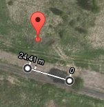
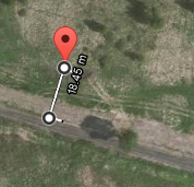
- In case the tree isn't standing there any more - distance from ditch's bend:
- Distance from a tree growing at the ditch, along and across:
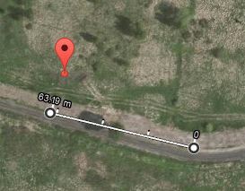
- I plan to earn the Juggernaut achievement. Here's a straight line from the nearest section of paved road close to my home:


Expedition
We've reached the spot, albeis not in so straight a line - boggy terrain.
Description will follow shortly.