Difference between revisions of "2015-04-26 47 -122"
imported>Thomcat ([live picture] Kerry Park iconic view [http://www.openstreetmap.org/?lat=47.62945426&lon=-122.35985286&zoom=16&layers=B000FTF @47.6295,-122.3599]) |
imported>Thomcat (Success #149, expedition #199) |
||
| Line 18: | Line 18: | ||
== Expedition == | == Expedition == | ||
| − | + | Extremely easy geohash, with a beautiful view. I arrived at just after 2pm on the street below, snapping a picture as I turned right. The geohashpoint was on the upper street, which is one way westbound (and quite narrow). | |
| + | |||
| + | I drove east, looped around and then headed west. Arriving at the likely location I parked, then stepped outside the car for hashdance purposes. Unfortunately, my hashdance kept bumping me into the car, so I rolled it back several meters and tried again. This time I got well within the accuracy of the gauge, less than a meter at two times. | ||
| + | |||
| + | I chalked the sidewalk and then snapped pictures of the chalk, the surroundings, and the iconic view. I then continued west to the counterbalance (so named for a streetcar that ran up the hill while a large weight moved down the hill underground) and then on to Kerry Park for an even more iconic Seattle view. | ||
| + | |||
| + | Geohash firmly scouted, I headed further west to Magnolia hill and the Sandy Koufax 14 year olds baseball league where I umpired two games, 3:30 and 6:30 start times. Clouds rolled in to spoil the sunny day, with a smattering of rain between the two games, but overall things went well. | ||
== Tracklog == | == Tracklog == | ||
| Line 47: | Line 53: | ||
| − | |||
| − | |||
| − | |||
[[Category:Expeditions]] | [[Category:Expeditions]] | ||
[[Category:Expeditions with photos]] | [[Category:Expeditions with photos]] | ||
[[Category:Coordinates reached]] | [[Category:Coordinates reached]] | ||
| − | |||
Revision as of 06:09, 27 April 2015
| Sun 26 Apr 2015 in Seattle: 47.6281640, -122.3518655 geohashing.info google osm bing/os kml crox |
Location
Queen Anne Hill in Seattle, with a view of the Space Needle.
Participants
Plans
Visit approximately 2pm, then head to Magnolia for two baseball games (weather permitting)
Expedition
Extremely easy geohash, with a beautiful view. I arrived at just after 2pm on the street below, snapping a picture as I turned right. The geohashpoint was on the upper street, which is one way westbound (and quite narrow).
I drove east, looped around and then headed west. Arriving at the likely location I parked, then stepped outside the car for hashdance purposes. Unfortunately, my hashdance kept bumping me into the car, so I rolled it back several meters and tried again. This time I got well within the accuracy of the gauge, less than a meter at two times.
I chalked the sidewalk and then snapped pictures of the chalk, the surroundings, and the iconic view. I then continued west to the counterbalance (so named for a streetcar that ran up the hill while a large weight moved down the hill underground) and then on to Kerry Park for an even more iconic Seattle view.
Geohash firmly scouted, I headed further west to Magnolia hill and the Sandy Koufax 14 year olds baseball league where I umpired two games, 3:30 and 6:30 start times. Clouds rolled in to spoil the sunny day, with a smattering of rain between the two games, but overall things went well.
Tracklog
Photos
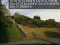
View from below @47.6280,-122.3528
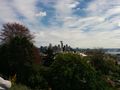
Kerry Park iconic view @47.6295,-122.3599


