Difference between revisions of "2015-05-05 52 1"
From Geohashing
imported>Sourcerer m (→New Expedition) |
imported>Sourcerer m (→Added Photo) |
||
| Line 26: | Line 26: | ||
<gallery perrow="5"> | <gallery perrow="5"> | ||
Image:2015-05-05_52_1_Sourcerer_1430859347975.jpg | [http://www.openstreetmap.org/?lat=52.07240582&lon=1.14132285&zoom=16&layers=B000FTF @52.0724,1.1413] | Image:2015-05-05_52_1_Sourcerer_1430859347975.jpg | [http://www.openstreetmap.org/?lat=52.07240582&lon=1.14132285&zoom=16&layers=B000FTF @52.0724,1.1413] | ||
| + | Image:2015-05-05_52_1_Sourcerer.jpg | Google Earth Track Log | ||
</gallery> | </gallery> | ||
Revision as of 14:25, 6 May 2015
| Tue 5 May 2015 in 52,1: 52.0723756, 1.1413283 geohashing.info google osm bing/os kml crox |
Location
In public parkland, north Ipswich, Suffolk, UK.
Participants
Expedition
Expedition one of two spanning midnight. 2015-05-05 52 1 2015-05-06 52 1
- Arrived. -- Sourcerer (talk) @52.0724,1.1413 21:56, 5 May 2015 (GMT+01:00)
The hashpoint was on a gravel path through woodland. The conditions were windy but dry and mild. The GPSr did not settle well but I was close enough.
Photos
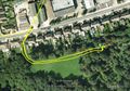
Google Earth Track Log


Achievements
Sourcerer earned the Consecutive geohash achievement
|
Other geohashing expeditions on the same day
Expeditions and Plans
| 2015-05-05 | ||
|---|---|---|
| Norwich, United Kingdom | Sourcerer | In public parkland, north Ipswich, Suffolk, UK. |