Difference between revisions of "2015-06-14 52 1"
From Geohashing
imported>Sourcerer m ([live picture] Proof. [http://www.openstreetmap.org/?lat=52.46993065&lon=1.50362492&zoom=16&layers=B000FTF @52.4699,1.5036]) |
imported>Sourcerer m (→New Expedition) |
||
| Line 19: | Line 19: | ||
== Expedition == | == Expedition == | ||
| + | *Arrived. -- [[User:Sourcerer|Sourcerer]] ([[User talk:Sourcerer|talk]]) [http://www.openstreetmap.org/?lat=52.46996284&lon=1.50364637&zoom=16&layers=B000FTF @52.4700,1.5036] 00:13, 14 June 2015 (GMT+01:00) | ||
| + | This went as planned. The only problem might have been livestock but the field was empty. A fence squeeze and a limbo manoeuvre under the electric fence got me into the field. Then it was a 50 metre walk, photos and the walk in reverse. | ||
| − | |||
| − | |||
== Photos == | == Photos == | ||
<gallery perrow="5"> | <gallery perrow="5"> | ||
| − | |||
| − | |||
Image:2015-06-14_52_1_Sourcerer_1434237271576.jpg | Proof. [http://www.openstreetmap.org/?lat=52.46993065&lon=1.50362492&zoom=16&layers=B000FTF @52.4699,1.5036] | Image:2015-06-14_52_1_Sourcerer_1434237271576.jpg | Proof. [http://www.openstreetmap.org/?lat=52.46993065&lon=1.50362492&zoom=16&layers=B000FTF @52.4699,1.5036] | ||
| + | Image:2015-06-14 52 1 Sourcerer.jpg | Google Earth Tracklog | ||
</gallery> | </gallery> | ||
== Achievements == | == Achievements == | ||
{{#vardefine:ribbonwidth|800px}} | {{#vardefine:ribbonwidth|800px}} | ||
| − | + | {{Midnight geohash | |
| + | | latitude = 52 | ||
| + | | longitude = 1 | ||
| + | | date = 2015-06-14 | ||
| + | | name = Sourcerer | ||
| + | }} | ||
| + | {{consecutive geohash 2 | ||
| + | | count = 6 | ||
| + | | latitude = 52 | ||
| + | | longitude = 1 | ||
| + | | date = 2015-06-09 | ||
| + | | name = Sourcerer | ||
| + | }} | ||
== Other geohashing expeditions on the same day == | == Other geohashing expeditions on the same day == | ||
| Line 39: | Line 50: | ||
{{expedition summaries|2015-06-14}} | {{expedition summaries|2015-06-14}} | ||
| − | |||
| − | |||
| − | |||
[[Category:Expeditions]] | [[Category:Expeditions]] | ||
[[Category:Expeditions with photos]] | [[Category:Expeditions with photos]] | ||
[[Category:Coordinates reached]] | [[Category:Coordinates reached]] | ||
| − | |||
Revision as of 23:48, 13 June 2015
| Sun 14 Jun 2015 in 52,1: 52.4699183, 1.5036281 geohashing.info google osm bing/os kml crox |
Location
In a field, west of Geldeston, Norfolk,UK.
Participants
Plans
I'll aim for a first midnight arrival. On my way to the shops after visiting 2015-06-13 52 1, I was able to survey barbed wire and an electric fence to be negotiated.
Expedition
- Arrived. -- Sourcerer (talk) @52.4700,1.5036 00:13, 14 June 2015 (GMT+01:00)
This went as planned. The only problem might have been livestock but the field was empty. A fence squeeze and a limbo manoeuvre under the electric fence got me into the field. Then it was a 50 metre walk, photos and the walk in reverse.
Photos
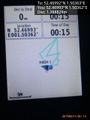
Proof. @52.4699,1.5036
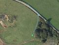
Google Earth Tracklog


Achievements
Sourcerer earned the Midnight Geohash achievement
|
Sourcerer earned the Consecutive geohash achievement
|
Other geohashing expeditions on the same day
Expeditions and Plans
| 2015-06-14 | ||
|---|---|---|
| Portland, Oregon | Jim | A little neighborhood park in Gresham |
| Mannheim, Germany | DODO | A residential street in Mannheim-Neuhermsheim. |
| Schweinfurt, Germany | Reinhard | Close to a gravel road near Jüchsen, Thuringia, Germany. |
| Norwich, United Kingdom | Sourcerer | In a field, west of Geldeston, Norfolk,UK. |