Difference between revisions of "2015-07-30 52 1"
From Geohashing
imported>Sourcerer m ([live] Arrived.) |
imported>Sourcerer m ([live picture] Proof. [http://www.openstreetmap.org/?lat=52.46059120&lon=1.18828297&zoom=16&layers=B000FTF @52.4606,1.1883]) |
||
| Line 27: | Line 27: | ||
<gallery perrow="5"> | <gallery perrow="5"> | ||
| + | |||
| + | Image:2015-07-30_52_1_Sourcerer_1438290760588.jpg | Proof. [http://www.openstreetmap.org/?lat=52.46059120&lon=1.18828297&zoom=16&layers=B000FTF @52.4606,1.1883] | ||
</gallery> | </gallery> | ||
Revision as of 21:14, 30 July 2015
| Thu 30 Jul 2015 in 52,1: 52.4605821, 1.1882657 geohashing.info google osm bing/os kml crox |
Location
Close to Narrowgate Way, Great Moulton, Norfolk, UK.
Participants
Plans
Expedition one of two spanning midnight - 2015-07-30 52 1 - 2015-07-31 52 1 - ETA 22:20.
Expedition
This hashpoint is 600 metres from 2015-07-08 52 1. With over 170 expeditions in 52, 1 this repetition is becoming increasingly common and useful too. I already know where to park and which side of the ditch to walk without getting wet.
- Arrived. -- Sourcerer (talk) @52.4606,1.1883 22:13, 30 July 2015 (GMT+01:00)
Photos
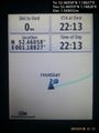
Proof. @52.4606,1.1883

Achievements
Expeditions and Plans
| 2015-07-30 | ||
|---|---|---|
| Agen, France | Someone went | In a field near the Garonne river |
| Kassel, Germany | GeorgDerReisende | The hash lay on a way between a forest and a field north of Wettesingen. |
| Norwich, United Kingdom | Sourcerer | Close to Narrowgate Way, Great Moulton, Norfolk, UK. |
| Emden, Germany | Mampfred, LadyBB, EmmJay | On a windy fild in northern germany. |
Sourcerer's Expedition Links
2015-07-29 52 0 - 2015-07-30 52 1 - 2015-07-31 52 1 - KML file download of Sourcerer's expeditions for use with Google Earth.