2015-07-31 52 1
| Fri 31 Jul 2015 in Norwich, UK: 52.0197918, 1.3427052 geohashing.info google osm bing/os kml crox |
Location
Between Kirton Lodge and the River Deben, Suffolk, UK.
Participants
Plans
Expedition two of two spanning midnight - 2015-07-30 52 1 - 2015-07-31 52 1 - ETA 00:00.
Expedition
- Arrived five minutes early. -- Sourcerer (talk) @52.0197,1.3427 23:55, 30 July 2015 (GMT+01:00)
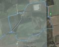
It's this sort of expedition that keeps me geohashing. There were fantastic moon lit views into the fog filled Deben estuary valley. The walk was outstanding in still cool air. The ripe wheat was glowing a silvery gold. The hashpoint was in a bean field. I think these are grown for fodder or perhaps bean flour. The pods were way too ripe for human consumption. I got my distance below 10 metres without damaging the crop. Instead of returning by the shortest route, I made a longer circular route for the pure joy of it. Wonderful.
I added some tracks to OpenStreetMap and corrected others which were labelled footpaths. In fact they were farm dirt roads with pedestrians permitted.
Photos
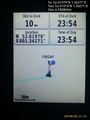
Proof. @52.0197,1.3427
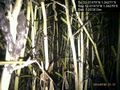
Bean crop. @52.0197,1.3427
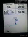
Still here. @52.0197,1.3427
Track in Google Earth
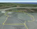
Track Overview in Google Earth


Achievements
Sourcerer earned the Midnight Geohash achievement
|
Sourcerer earned the OpenStreetMap achievement
|
Expeditions and Plans
| 2015-07-31 | ||
|---|---|---|
| Aurora, Illinois | Rookiek13, Kiamx | Curbside in a downtown Naperville subdivision |
| McMinnville, Oregon | Jim | Ag land north of Hwy 26 |
| München, Germany | TheOneRing | in a forest near Starnberg. |
| Wien, Austria | G* | In a field near Guntramsdorf, about 10km east of Baden. |
| Mannheim, Germany | elimik31 | Karlsruhe, Rheinhafen (Rhine harbor), Wikingerstraße, near the hill with th... |
| Norwich, United Kingdom | Sourcerer | Between Kirton Lodge and the River Deben, Suffolk, UK. |
| Amsterdam, Netherlands | FelixTheCat | Inside DSM Chemical Plant, Delft. |
Sourcerer's Expedition Links
2015-07-30 52 1 - 2015-07-31 52 1 - 2015-08-01 52 0 - KML file download of Sourcerer's expeditions for use with Google Earth.