Difference between revisions of "2015-11-02 52 1"
From Geohashing
imported>Sourcerer m ([live picture] Proof. [http://www.openstreetmap.org/?lat=52.36285150&lon=1.61381006&zoom=16&layers=B000FTF @52.3629,1.6138]) |
imported>Sourcerer m (→New expedition) |
||
| Line 16: | Line 16: | ||
== Plans == | == Plans == | ||
| − | + | There was no suitable point to make a midnight pairing. | |
== Expedition == | == Expedition == | ||
| + | *Arrived. -- [[User:Sourcerer|Sourcerer]] ([[User talk:Sourcerer|talk]]) [http://www.openstreetmap.org/?lat=52.36285150&lon=1.61380470&zoom=16&layers=B000FTF @52.3629,1.6138] 21:58, 2 November 2015 (GMT) | ||
| + | This was a double hash. I visited [[2015-11-02 52 0]] earlier in thick fog. Just over four hours later, the wind had changed and it was crystal clear. This expedition was easy and quite close to home. There was a roadside parking place and the hashpoint was a short distance into a field of oil seed rape seedlings. | ||
| − | |||
== Photos == | == Photos == | ||
<gallery> | <gallery> | ||
| − | |||
| − | |||
Image:2015-11-02_52_1_Sourcerer_1446501431165.jpg | Proof. [http://www.openstreetmap.org/?lat=52.36285150&lon=1.61381006&zoom=16&layers=B000FTF @52.3629,1.6138] | Image:2015-11-02_52_1_Sourcerer_1446501431165.jpg | Proof. [http://www.openstreetmap.org/?lat=52.36285150&lon=1.61381006&zoom=16&layers=B000FTF @52.3629,1.6138] | ||
| + | Image:2015-11-02_52_1_Sourcerer.jpg | Track in Google Earth. | ||
</gallery> | </gallery> | ||
| Line 40: | Line 40: | ||
}} | }} | ||
| − | |||
| − | |||
[[Category:Expeditions]] | [[Category:Expeditions]] | ||
[[Category:Expeditions with photos]] | [[Category:Expeditions with photos]] | ||
[[Category:Coordinates reached]] | [[Category:Coordinates reached]] | ||
| − | |||
Revision as of 22:52, 2 November 2015
| Mon 2 Nov 2015 in 52,1: 52.3628668, 1.6138206 geohashing.info google osm bing/os kml crox |
Location
In a field east of Uggeshall, Suffolk, UK.
Participants
Plans
There was no suitable point to make a midnight pairing.
Expedition
- Arrived. -- Sourcerer (talk) @52.3629,1.6138 21:58, 2 November 2015 (GMT)
This was a double hash. I visited 2015-11-02 52 0 earlier in thick fog. Just over four hours later, the wind had changed and it was crystal clear. This expedition was easy and quite close to home. There was a roadside parking place and the hashpoint was a short distance into a field of oil seed rape seedlings.
Photos
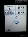
Proof. @52.3629,1.6138
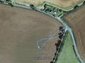
Track in Google Earth.


Achievements
Expeditions and Plans
| 2015-11-02 | ||
|---|---|---|
| Seattle, Washington | Thomcat | The north plaza of Century Link field. |
| Mannheim, Germany | Lord Vetinari, DODO | The hash is located near Schwetzingen/Oftersheim in a field between two str... |
| Cambridge, United Kingdom | Sourcerer | 1) Woodland just south of the A11 and 1000 metres west of Elveden War Memor... |
| Norwich, United Kingdom | Sourcerer | 2) In a field east of Uggeshall, Suffolk, UK. |
Sourcerer's Expedition Links
2015-11-02 52 0 - 2015-11-02 52 1 - 2015-11-04 52 1 - KML file download of Sourcerer's expeditions for use with Google Earth.