Difference between revisions of "2015-11-02 47 -122"
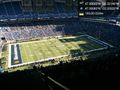
imported>Thomcat ([retro picture]From season ticket seats [http://www.openstreetmap.org/?lat=47.59583080&lon=-122.33332950&zoom=16&layers=B000FTF @47.5958,-122.3333]) |
imported>Thomcat (→Expedition: revisit) |
||
| Line 21: | Line 21: | ||
I then headed up the steps, to find a second set of gates I never noticed before. Happy to find the field closed but the plaza open, I further documented my success and headed to work. | I then headed up the steps, to find a second set of gates I never noticed before. Happy to find the field closed but the plaza open, I further documented my success and headed to work. | ||
| − | We do love our cloverleafs (though probably not as much as road planners in southern California) but I managed to plot a route to work that avoided them. What I didn't avoid was traffic, and the commute consumed quite a bit more time than usual. My route home will be more traditional, around the north end of the lake, completing my [[Tron achievement|loop]]. | + | We do love our cloverleafs (though probably not as much as road planners in southern California) but I managed to plot a route to work that avoided them. What I didn't avoid was traffic, and the commute consumed quite a bit more time than usual. My route home will be more traditional, around the north end of the lake, completing my [[Tron achievement|loop]]. |
| + | |||
| + | ===November 22 addendum=== | ||
| + | Joined a friend for the game today, walked right over the spot. Earlier in the day I updated to the newest geohashdroid, so today was a good chance to test it out (since today's actual point was inaccessible on the peninsula). My only (minor) complaint is that when I switch away from the app, the date reverts to today - so the picture below is actually my second upload. | ||
== Tracklog == | == Tracklog == | ||
Revision as of 14:10, 23 November 2015
| Mon 2 Nov 2015 in Seattle: 47.5964260, -122.3314650 geohashing.info google osm bing/os kml crox |
Location
The north plaza of Century Link field.
Participants
Expedition
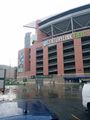
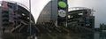
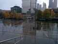
This is a spot crossed by thousands of people on days with (American) Football or Soccer (Football) games. Through a circuitous route, I could visit the area and then continue across a floating bridge to my place of work.
I expected this plaza to be closed, as the stadium steps are nearby and the seats and field beyond. Arriving, I was pleasantly surprised to find the gates open, and quickly found the spot in a light rain.
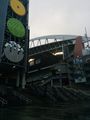
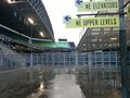
I then headed up the steps, to find a second set of gates I never noticed before. Happy to find the field closed but the plaza open, I further documented my success and headed to work.
We do love our cloverleafs (though probably not as much as road planners in southern California) but I managed to plot a route to work that avoided them. What I didn't avoid was traffic, and the commute consumed quite a bit more time than usual. My route home will be more traditional, around the north end of the lake, completing my loop.
November 22 addendum
Joined a friend for the game today, walked right over the spot. Earlier in the day I updated to the newest geohashdroid, so today was a good chance to test it out (since today's actual point was inaccessible on the peninsula). My only (minor) complaint is that when I switch away from the app, the date reverts to today - so the picture below is actually my second upload.
Tracklog
I will save a tracklog expedition for a geohash closer to home.
Photos
Still broken
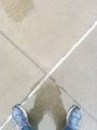
"X" marks the spot?


Today's attire
From season ticket seats @47.5958,-122.3333


