Difference between revisions of "2016-01-04 51 1"
From Geohashing
imported>Sourcerer m (→Planning) |
imported>Sourcerer m ([live picture] Arrival proof. [http://www.openstreetmap.org/?lat=51.90739095&lon=1.15543127&zoom=16&layers=B000FTF @51.9074,1.1554]) |
||
| Line 25: | Line 25: | ||
== Photos == | == Photos == | ||
<gallery> | <gallery> | ||
| + | |||
| + | Image:2016-01-04_51_1_Sourcerer_1451949538890.jpg | Arrival proof. [http://www.openstreetmap.org/?lat=51.90739095&lon=1.15543127&zoom=16&layers=B000FTF @51.9074,1.1554] | ||
</gallery> | </gallery> | ||
Revision as of 23:21, 4 January 2016
| Mon 4 Jan 2016 in Canterbury, UK: 51.9073868, 1.1554141 geohashing.info google osm bing/os kml crox |
Location
3) In a field, south of Wrabness and the river Stour, Suffolk, UK.
Participants
Plans
Expedition three of four spanning midnight - 2015-11-08 52 1 Retro - 2016-01-04 52 1 - 2016-01-04 51 1 - 2016-01-05 52 0 - ETA 23:00.
Expedition
Photos
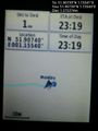
Arrival proof. @51.9074,1.1554

Achievements
Expeditions and Plans
| 2016-01-04 | ||
|---|---|---|
| Nürnberg, Germany | Klaus | field close to the borders of Hohenpölz |
| Bonn, Germany | Burgman | A small path in Rösrath. |
| Canterbury, United Kingdom | Sourcerer | 3) In a field, south of Wrabness and the river Stour, Suffolk, UK. |
| Norwich, United Kingdom | Sourcerer | 2) In a field west of Bodham close and All Saints Church, Norfolk, UK. |
Sourcerer's Expedition Links
2016-01-04 52 1 - 2016-01-04 51 1 - 2016-01-05 52 0 - KML file download of Sourcerer's expeditions for use with Google Earth.