Difference between revisions of "2016-01-21 52 1"
From Geohashing
imported>Sourcerer m (→Expedition) |
imported>FippeBot m (Location) |
||
| Line 42: | Line 42: | ||
[[Category:Expeditions with photos]] | [[Category:Expeditions with photos]] | ||
[[Category:Coordinates reached]] | [[Category:Coordinates reached]] | ||
| + | {{location|GB|ENG|SFK}} | ||
Latest revision as of 06:31, 15 August 2019
| Thu 21 Jan 2016 in Norwich, UK: 52.4022049, 1.3846535 geohashing.info google osm bing/os kml crox |
Location
A field south east of Saint Cross South Elmham, Suffolk, UK.
Participants
Plans
There were no local points to make a pair.
Expedition
This was close to home. After a short moonlit drive and an even shorter walk, the hashpoint was 10 metres from the grassy field perimeter path. This was my first expedition using my home-grown coordinate calculator. This loads a kml file into Google Earth or similar applications.
Photos
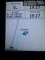
Arrival proof. @52.4022,1.3846
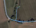
Google Earth Track


Achievements
Expeditions and Plans
| 2016-01-21 | ||
|---|---|---|
| Norwich, United Kingdom | Sourcerer | A field south east of Saint Cross South Elmham, Suffolk, UK. |
| Utrecht, Netherlands | JwB | A field in Flevoland |
| Närpiö, Finland | thestormer | A cow field in Närpes next to route 67. |
Sourcerer's Expedition Links
2016-01-16 52 1 - 2016-01-21 52 1 - 2016-01-22 52 0 - KML file download of Sourcerer's expeditions for use with Google Earth.