Difference between revisions of "2016-01-22 52 0"
From Geohashing
imported>Sourcerer (→Planning) |
imported>Sourcerer m (Arrival proof [http://www.openstreetmap.org/?lat=52.87811995&lon=.60266554&zoom=16&layers=B000FTF @52.8781,.6027]) |
||
| Line 25: | Line 25: | ||
== Photos == | == Photos == | ||
<gallery> | <gallery> | ||
| + | |||
| + | Image:2016-01-22_52_0_Sourcerer_-1.jpg | Arrival proof [http://www.openstreetmap.org/?lat=52.87811995&lon=.60266554&zoom=16&layers=B000FTF @52.8781,.6027] | ||
</gallery> | </gallery> | ||
Revision as of 22:41, 22 January 2016
| Fri 22 Jan 2016 in Cambridge, UK: 52.8781187, 0.6026517 geohashing.info google osm bing/os kml crox |
Location
1) In a field north west of Great Bircham, Norfolk, UK.
Participants
Plans
Expedition one of two spanning midnight - 2016-01-22 52 0 - 2016-01-23 52 0 - ETA 22:40.
Expedition
Photos
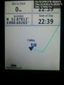
Arrival proof @52.8781,.6027

Achievements
Expeditions and Plans
| 2016-01-22 | ||
|---|---|---|
| Erfurt, Germany | Juja, Davey | Practically on the Saaleradweg (cycleway) on the edge of Jena, near the mot... |
| Cambridge, United Kingdom | Sourcerer | A field north west of Great Bircham, Norfolk, UK. |
Sourcerer's Expedition Links
2016-01-21 52 1 - 2016-01-22 52 0 - 2016-01-23 52 0 - KML file download of Sourcerer's expeditions for use with Google Earth.