Difference between revisions of "2016-03-29 52 1"
From Geohashing
imported>Sourcerer m ([live] Arrived at midnight. No 3G at hashpoint. Home broadband is down. Atlantic store Kate perhaps.) |
imported>Sourcerer m (→New expedition) |
||
| Line 1: | Line 1: | ||
| − | + | {{meetup graticule | |
| − | |||
| − | |||
| − | |||
| − | |||
| − | |||
| − | |||
| − | |||
| − | |||
| − | |||
| − | {{meetup graticule | ||
| lat=52 | | lat=52 | ||
| lon=1 | | lon=1 | ||
| date=2016-03-29 | | date=2016-03-29 | ||
| + | | graticule_name=Norwich, UK | ||
| + | | graticule_link=Norwich, United Kingdom | ||
}} | }} | ||
| − | |||
| − | |||
__NOTOC__ | __NOTOC__ | ||
| + | == Location == | ||
| − | + | A field close to the Industrial Estate at Rackheath, Norfolk, UK. | |
| − | |||
== Participants == | == Participants == | ||
| − | |||
| − | |||
| − | + | *[[User:Sourcerer|Sourcerer]] | |
| − | |||
== Expedition == | == Expedition == | ||
| − | |||
| + | *Arrived at midnight. No 3G at hashpoint. Home broadband is down. Atlantic store Katie perhaps. -- [[User:Sourcerer|Sourcerer]] ([[User talk:Sourcerer|talk]]) [http://www.openstreetmap.org/?lat=52.45957610&lon=1.44027160&zoom=16&layers=B000FTF @52.4596,1.4403] 00:59, 29 March 2016 (GMT+01:00) | ||
| + | |||
| + | Expedition three of three spanning midnight - [[2016-03-28 52 1]] - [[2014-09-18 52 1 | 2014-09-18 52 1 Retro]] - [[2016-03-29 52 1]] - ETA 00:00. | ||
| − | + | There was a concrete access road followed by a field perimeter path. The hashpoint was about 15 metres from the field edge. | |
| − | |||
| − | |||
== Photos == | == Photos == | ||
| − | + | ||
| − | |||
| − | |||
<gallery perrow="5"> | <gallery perrow="5"> | ||
| + | Image:2016-03-29 52 1 Sourcerer Track.jpg | Google Earth Track. | ||
| + | Image:2016-03-29 52 1 Sourcerer.jpg | Proof. | ||
</gallery> | </gallery> | ||
== Achievements == | == Achievements == | ||
{{#vardefine:ribbonwidth|800px}} | {{#vardefine:ribbonwidth|800px}} | ||
| − | |||
| − | + | {{Sourcerer_links | |
| − | + | | prev = 2016-03-28 52 1 | |
| − | + | | curr = 2016-03-29 52 1 | |
| − | + | | next = 2016-03-30 52 1 | |
| − | + | | date = 2016-03-29 | |
| − | + | }} | |
| − | |||
| − | -- | ||
| − | |||
| − | |||
| − | |||
[[Category:Expeditions]] | [[Category:Expeditions]] | ||
| − | |||
[[Category:Expeditions with photos]] | [[Category:Expeditions with photos]] | ||
| − | |||
| − | |||
| − | |||
| − | |||
| − | |||
[[Category:Coordinates reached]] | [[Category:Coordinates reached]] | ||
| − | |||
| − | |||
| − | |||
| − | |||
| − | |||
| − | |||
| − | |||
| − | |||
| − | |||
| − | |||
| − | |||
| − | |||
| − | |||
| − | |||
| − | |||
| − | |||
| − | |||
| − | |||
Revision as of 01:03, 29 March 2016
| Tue 29 Mar 2016 in Norwich, UK: 52.6717039, 1.3680732 geohashing.info google osm bing/os kml crox |
Location
A field close to the Industrial Estate at Rackheath, Norfolk, UK.
Participants
Expedition
- Arrived at midnight. No 3G at hashpoint. Home broadband is down. Atlantic store Katie perhaps. -- Sourcerer (talk) @52.4596,1.4403 00:59, 29 March 2016 (GMT+01:00)
Expedition three of three spanning midnight - 2016-03-28 52 1 - 2014-09-18 52 1 Retro - 2016-03-29 52 1 - ETA 00:00.
There was a concrete access road followed by a field perimeter path. The hashpoint was about 15 metres from the field edge.
Photos
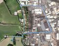
Google Earth Track.
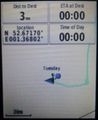
Proof.


Achievements
Expeditions and Plans
| 2016-03-29 | ||
|---|---|---|
| Melbourne West, Australia | Someone went | 380 metres from the car park at the end of Myers Road in Werribee Gorge, ne... |
| Mannheim, Germany | DODO | An island between the Rhine and an old branch between Biblis and Bürstadt. |
| Norwich, United Kingdom | Sourcerer, ChromeCrusaders | A field close to the Industrial Estate at Rackheath, Norfolk, UK. |
| Seinäjoki, Finland | thestormer, Adalwinda | A field near Koskenkorva |
Sourcerer's Expedition Links
2016-03-28 52 1 - 2016-03-29 52 1 - 2016-03-30 52 1 - KML file download of Sourcerer's expeditions for use with Google Earth.