Difference between revisions of "2016-06-02 52 1"
From Geohashing
imported>Sourcerer m (→Achievements) |
imported>FippeBot m (Location) |
||
| Line 50: | Line 50: | ||
[[Category:Expeditions with photos]] | [[Category:Expeditions with photos]] | ||
[[Category:Coordinates reached]] | [[Category:Coordinates reached]] | ||
| + | {{location|GB|ENG|SFK}} | ||
Latest revision as of 00:41, 16 August 2019
| Thu 2 Jun 2016 in Norwich, UK: 52.0433326, 1.2643468 geohashing.info google osm bing/os kml crox |
Location
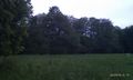
A pretty meadow trapped between a busy road, a refuse recycling plant and a quarry near Brightwell, Suffolk, UK.
Participants
Expedition
It was hard to find a safe place to park. Then there was a walk of a few hundred metres on a busy road. Finally there was a nicer public footpath leading towards the point which was approximately on the path between two bridged streams. This was a delightful spot surrounded by traffic noise, quarrying and refuse recycling.
Photos
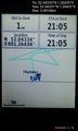
Arrived. @52.0433,1.2643
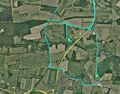
Google Earth Track
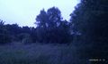
View
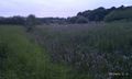
View
View


Achievements
Sourcerer earned the OpenStreetMap achievement
|
Expeditions and Plans
| 2016-06-02 | ||
|---|---|---|
| Mannheim, Germany | RecentlyChanged | On a dead end street, maybe in an industrial area. |
| Norwich, United Kingdom | Sourcerer | A pretty meadow trapped between a busy road, a refuse recycling plant and a... |
Sourcerer's Expedition Links
2016-06-01 52 1 - 2016-06-02 52 1 - 2016-06-07 52 1 - KML file download of Sourcerer's expeditions for use with Google Earth.