Difference between revisions of "2016-06-12 52 1"
From Geohashing
imported>Sourcerer (→New expedition) |
imported>Sourcerer m (→Photos) |
||
| Line 21: | Line 21: | ||
== Photos == | == Photos == | ||
| − | <gallery perrow="3"> | + | <gallery caption="Photo Gallery" widths="200px" heights="200px" perrow="3"> |
Image:2016-06-12 52 1 Sourcerer 1.jpg | Google Earth Track | Image:2016-06-12 52 1 Sourcerer 1.jpg | Google Earth Track | ||
Image:2016-06-12 52 1 Sourcerer 2.jpg | Woodland | Image:2016-06-12 52 1 Sourcerer 2.jpg | Woodland | ||
Revision as of 15:28, 16 June 2016
| Sun 12 Jun 2016 in Norwich, UK: 52.7085367, 1.2305191 geohashing.info google osm bing/os kml crox |
Location
Saint Faith's Common, Horsford, Norfolk, UK.
Participants
Expedition - Fail
On a damp Sunday evening there was little traffic. There was car parking at the common. A woodland path led in the right direction but the hashpoint field was very well fenced. 20 metres from the destination there was no possibility of getting closer.
Photos
- Photo Gallery
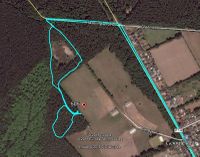
Google Earth Track
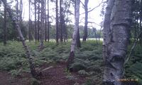
Woodland
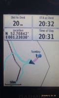
Fail Proof
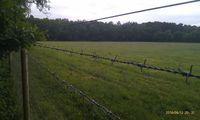
The dreaded fence
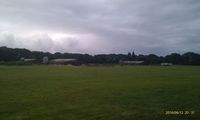
Farm buildings


Achievements
Expeditions and Plans
| 2016-06-12 | ||
|---|---|---|
| Wichita, Kansas | thunk | Near the entrance to a private club building in Wichita, Kansas, USA. |
| London East, United Kingdom | Mehar Xull | Somewhere |
| Norwich, United Kingdom | Sourcerer | Saint Faith's Common, Horsford, Norfolk, UK. |
| Globalhash | thunk | About 2 km north of Douglass, Butler County, Kansas, USA. The hash location... |
Sourcerer's Expedition Links
2016-06-11 52 1 - 2016-06-12 52 1 - 2016-06-13 52 1 - KML file download of Sourcerer's expeditions for use with Google Earth.