Difference between revisions of "2016-08-21 47 8"
imported>Chris 47 8 m (Oarticipant and location) |
imported>Chris 47 8 (exp added) |
||
| Line 1: | Line 1: | ||
| − | |||
| − | |||
| − | |||
| − | |||
| − | |||
| − | |||
| − | |||
| − | |||
| − | |||
{{meetup graticule | {{meetup graticule | ||
| lat=47 | | lat=47 | ||
| Line 15: | Line 6: | ||
}} | }} | ||
| − | |||
__NOTOC__ | __NOTOC__ | ||
| Line 28: | Line 18: | ||
== Expedition == | == Expedition == | ||
| − | + | So this hash was very conveniently located in the middle of Winterthur on a sunny sunday afternoon. I went there by bus and found the place immediately. On the way there, i found a QR code on a sign next to a buidling. I didn't check it yet, might be an art project. The hash itself was right next to a street on a meadow. No fence or anything there, so super easy to reach. I checked to coordinates and took some photos, there was nothing nearby that's worth to be mentioned. On the way back i found a nice street sign saying Palm Street, something which is, i would say, quite uncommon in Switzerland. It also indicated the way to Villa Flora, which is an art museum, Technorama, which is a science and technology museum for kids, and the Fotomuseum. Winterthur is a museum city. Oh and it also had a clock on it, because we're in Switzerland. Plus: 2 to the 5! | |
== Tracklog == | == Tracklog == | ||
<!-- if your GPS device keeps a log, you may post a link here --> | <!-- if your GPS device keeps a log, you may post a link here --> | ||
| − | == Photos == | + | == Photos == |
| − | < | + | |
| − | Image: | + | <gallery perrow="4"> |
| − | + | Image:2016082147801.jpg|A QR code if found nearby | |
| − | + | Image:2016082147802.jpg|Coords reached | |
| + | Image:2016082147803.jpg|Facing east | ||
| + | Image:2016082147804.jpg|West | ||
| + | Image:2016082147805.jpg|Big old trees | ||
| + | Image:2016082147806.jpg|Palm street | ||
</gallery> | </gallery> | ||
== Achievements == | == Achievements == | ||
{{#vardefine:ribbonwidth|800px}} | {{#vardefine:ribbonwidth|800px}} | ||
| − | + | {{Two to the N achievement | count = 5 | latitude = 47 | longitude = 8 | date = 2016-08-21 | reached = true | name = Chris_47_8 }} | |
| − | |||
| − | |||
| − | |||
| − | |||
| − | |||
| − | |||
| − | |||
| − | |||
| − | |||
| − | |||
| − | |||
| − | |||
| − | |||
| − | |||
[[Category:Expeditions]] | [[Category:Expeditions]] | ||
| − | |||
[[Category:Expeditions with photos]] | [[Category:Expeditions with photos]] | ||
| − | |||
| − | |||
| − | |||
| − | |||
| − | |||
[[Category:Coordinates reached]] | [[Category:Coordinates reached]] | ||
| − | |||
| − | |||
| − | |||
| − | |||
| − | |||
| − | |||
| − | |||
| − | |||
| − | |||
| − | |||
| − | |||
| − | |||
| − | |||
| − | |||
| − | |||
| − | |||
| − | |||
| − | |||
Revision as of 20:18, 21 August 2016
| Sun 21 Aug 2016 in 47,8: 47.4923943, 8.7350583 geohashing.info google osm bing/os kml crox |
Location
Next to Zeughausstrasse in Winterthur.
Participants
Plans
Go there by bus in the afternoon.
Expedition
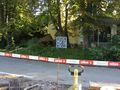
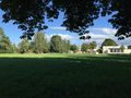
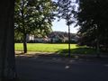
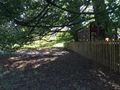
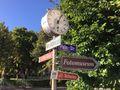
So this hash was very conveniently located in the middle of Winterthur on a sunny sunday afternoon. I went there by bus and found the place immediately. On the way there, i found a QR code on a sign next to a buidling. I didn't check it yet, might be an art project. The hash itself was right next to a street on a meadow. No fence or anything there, so super easy to reach. I checked to coordinates and took some photos, there was nothing nearby that's worth to be mentioned. On the way back i found a nice street sign saying Palm Street, something which is, i would say, quite uncommon in Switzerland. It also indicated the way to Villa Flora, which is an art museum, Technorama, which is a science and technology museum for kids, and the Fotomuseum. Winterthur is a museum city. Oh and it also had a clock on it, because we're in Switzerland. Plus: 2 to the 5!
Tracklog
Photos
A QR code if found nearby
Coords reached
Facing east
West
Big old trees
Palm street


Achievements
Chris_47_8 earned the Two to the N achievement
|