Difference between revisions of "2017-04-03 52 1"
From Geohashing
imported>Sourcerer m ([live picture] Arrived. [http://www.openstreetmap.org/?lat=52.46257067&lon=1.33225858&zoom=16&layers=B000FTF @52.4626,1.3323]) |
imported>Sourcerer m (→New expedition) |
||
| Line 1: | Line 1: | ||
| − | + | {{meetup graticule | |
| − | |||
| − | |||
| − | |||
| − | |||
| − | |||
| − | |||
| − | |||
| − | |||
| − | |||
| − | {{meetup graticule | ||
| lat=52 | | lat=52 | ||
| lon=1 | | lon=1 | ||
| date=2017-04-03 | | date=2017-04-03 | ||
| + | | graticule_name=Norwich, UK | ||
| + | | graticule_link=Norwich, United Kingdom | ||
}} | }} | ||
| − | |||
| − | |||
__NOTOC__ | __NOTOC__ | ||
| + | == Location == | ||
| − | + | A field north of Alburgh, Norfolk, UK. | |
| − | |||
== Participants == | == Participants == | ||
| − | + | ||
| − | + | [[User:Sourcerer|Sourcerer]] | |
== Plans == | == Plans == | ||
| − | + | ||
| + | Went on a whim to take advantage of nice spring weather. | ||
== Expedition == | == Expedition == | ||
| − | |||
| − | |||
| − | |||
| − | |||
| − | + | The hashpoint was 5 metres off a public footpath in a wheat crop. It could hardly have been easier and it was less than 5 miles from home. | |
| − | |||
| − | |||
| − | |||
| − | |||
| + | == Photos == | ||
| + | <gallery caption="Gallery" widths="200px" heights="200px" perrow="3"> | ||
Image:2017-04-03_52_1_Sourcerer_1491230227798.jpg | Arrived. [http://www.openstreetmap.org/?lat=52.46257067&lon=1.33225858&zoom=16&layers=B000FTF @52.4626,1.3323] | Image:2017-04-03_52_1_Sourcerer_1491230227798.jpg | Arrived. [http://www.openstreetmap.org/?lat=52.46257067&lon=1.33225858&zoom=16&layers=B000FTF @52.4626,1.3323] | ||
| + | Image:2017-04-03_52_1_Sourcerer.jpg | Google Earth Track | ||
| + | Image:2017-04-03_52_1_Sourcerer-b.jpg | View | ||
</gallery> | </gallery> | ||
== Achievements == | == Achievements == | ||
{{#vardefine:ribbonwidth|800px}} | {{#vardefine:ribbonwidth|800px}} | ||
| − | |||
| − | + | {{Sourcerer_links | |
| − | + | | prev = 2017-03-18 52 1 | |
| − | + | | curr = 2017-04-03 52 1 | |
| + | | next = 2017-04-05 | ||
| + | | date = 2017-04-03 | ||
| + | }} | ||
| − | |||
| − | |||
| − | |||
| − | |||
| − | |||
| − | |||
| − | |||
| − | |||
| − | |||
| − | |||
[[Category:Expeditions]] | [[Category:Expeditions]] | ||
| − | |||
[[Category:Expeditions with photos]] | [[Category:Expeditions with photos]] | ||
| − | |||
| − | |||
| − | |||
| − | |||
| − | |||
[[Category:Coordinates reached]] | [[Category:Coordinates reached]] | ||
| − | |||
| − | |||
| − | |||
| − | |||
| − | |||
| − | |||
| − | |||
| − | |||
| − | |||
| − | |||
| − | |||
| − | |||
| − | |||
| − | |||
| − | |||
| − | |||
| − | |||
| − | |||
Revision as of 15:41, 3 April 2017
| Mon 3 Apr 2017 in Norwich, UK: 52.4625182, 1.3322727 geohashing.info google osm bing/os kml crox |
Location
A field north of Alburgh, Norfolk, UK.
Participants
Plans
Went on a whim to take advantage of nice spring weather.
Expedition
The hashpoint was 5 metres off a public footpath in a wheat crop. It could hardly have been easier and it was less than 5 miles from home.
Photos
- Gallery
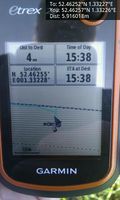
Arrived. @52.4626,1.3323
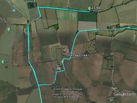
Google Earth Track
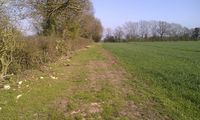
View


Achievements
Expeditions and Plans
| 2017-04-03 | ||
|---|---|---|
| Dortmund, Germany | Fubini | In a small forest in the town of Bochum. |
| Norwich, United Kingdom | Sourcerer | A field north of Alburgh, Norfolk, UK. |
Sourcerer's Expedition Links
2017-03-18 52 1 - 2017-04-03 52 1 - 2017-04-05 - KML file download of Sourcerer's expeditions for use with Google Earth.