Difference between revisions of "2017-05-21 48 7"
imported>DODO |
imported>DODO (→Achievements) |
||
| Line 65: | Line 65: | ||
<!-- Add any achievement ribbons you earned below, or remove this section --> | <!-- Add any achievement ribbons you earned below, or remove this section --> | ||
| − | + | {{land geohash | |
| − | + | | latitude = 48 | |
| − | + | | longitude = 7 | |
| + | | date = 2017-05-21 | ||
| + | | name = DODO | ||
| + | }} | ||
| − | + | {{Geohashing Day | |
| + | | latitude = 48 | ||
| + | | longitude = 7 | ||
| + | | year = 2017 | ||
| + | | coorddate = 2017-05-21 | ||
| + | | name = DODO | ||
| + | }} | ||
| − | + | {{Border geohash achievement | |
| − | + | | latitude = 48 | |
| − | + | | longitude = 7 | |
| − | + | | date = 2017-05-21 | |
| + | | country1 = France | ||
| + | | country2 = Germany | ||
| + | | name = DODO | ||
| + | }} | ||
| − | + | {{Reverse Regional | |
| + | | latitude = 48 | ||
| + | | longitude = 7 | ||
| + | | name = DODO | ||
| + | | count = 2 | ||
| + | | graticule = Strassbourg, France | ||
| + | | level = '''countries''' | ||
| + | }} | ||
| − | |||
[[Category:Expeditions]] | [[Category:Expeditions]] | ||
| − | |||
[[Category:Expeditions with photos]] | [[Category:Expeditions with photos]] | ||
| − | |||
| − | |||
| − | |||
| − | |||
| − | |||
[[Category:Coordinates reached]] | [[Category:Coordinates reached]] | ||
| − | |||
| − | |||
| − | |||
| − | |||
| − | |||
| − | |||
| − | |||
| − | |||
| − | |||
| − | |||
| − | |||
| − | |||
| − | |||
| − | |||
| − | |||
| − | |||
| − | |||
| − | |||
Revision as of 17:56, 21 May 2017
| Sun 21 May 2017 in 48,7: 48.6624344, 7.9684885 geohashing.info google osm bing/os kml crox |
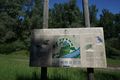
Location
Next to a forest path near Rheinau-Freistett.
Participants
Plans
I have time, the ladies are at work, the weather is fine and the location promises a lot of shiny ribbons (and at least it's geohashing day). What else could I do than go there. It's a nice distance for an extended bullride.
Expedition
I started in the morning at half past nine after doing some homework. I knew that there would be a train from Achern at 15:16 that would bring me home. Usually by far enough time.
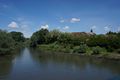
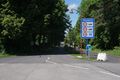
The trip started uneventful and nice. After almost 2 hours and a bit more than 50 kilometers I must have crossed the french border without even remarking it before I saw the first signs written in french. I continued my way that lead me along the river rhine most of the time. After I've passed the lock at Iffezheim, I couldn't see the river anymore because it was behind a dike and up to 7 meters above me.Almost two hours (and 40 kilometers) later I reched the ferry at Gambsheim, where I had to leave France again. This time I took some pictures. On the German bank I had a short break for an ice-cream. Then I reached the river Rench, followed it for a while until it was just 1 more kilometer to the hash. I left the river and cycled into the forest. The hash lied almost directly next to the path but gps reception wasn't good as soon as I left the path. So I didn't get closer than 2,5 m. Anyway, I call it good enough and continued my ride to Achern. I reached the station almost one hour before my train leaves. Enough time for some cake, some beer and a little sightseeing. Well, the last part wasn't very impressing, but the other two were :-)
Tracklog
122 KM bullriding and 101 KM by train
Photos
Sign in France. You can see the arrow where I am and where I must have crossed the border
french village
leaving France again ...
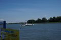
...on this ferry. Surprise: The ferry is for free!
ice-cream (ferry in the background)
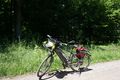
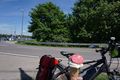
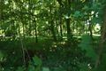
I left the bull mnear the hash
view to the hash from the path
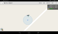
proof
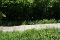
view to the path from the hash
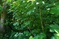
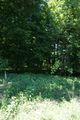
It's close to the thicket
on the other side of the thicket

happy hasher
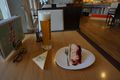
and what makes a succesfull hasher happy


Achievements
DODO earned the Land geohash achievement
|
DODO earned the 2017 Geohashing Day achievement
|
DODO earned the Border geohash achievement
|
DODO earned the Reverse regional achievement
|