Difference between revisions of "2019-02-03 45 -123"
imported>Michael5000 m (→Location) |
imported>Michael5000 |
||
| Line 23: | Line 23: | ||
== Participants == | == Participants == | ||
| − | |||
| − | |||
| − | + | [[user:Michael5000|Michael5000]] | |
| − | |||
== Expedition == | == Expedition == | ||
| − | + | ||
| + | The little village of Amity is in agricultural country about an hour's drive southwest of Portland. It's cute. There's a nice park at the southwest edge, and I parked there and ran about two miles to the hashpoint, which was placed with convenient road access. It was unfortunately about the least scenic specific place in the area, but that's where the hashpoint was so that's where I took my pictures. Then, I continued down Briedwell Road to the north, then headed back east to catch the fetchingly named Hook and Eye Road, which let me loop back towards the starting point. It was a very scenic run through orchards and fields, and at 8.13 broke my distance record for Yamhill County. It was also my first expedition to the McMinnville graticule portion of Yamhill County. | ||
== Tracklog == | == Tracklog == | ||
| − | < | + | |
| + | Not technically a "Tracklog," but fitting the bill: | ||
| + | <gallery perrow="5"> | ||
| + | File:2019-02-03 45 -123 Route.JPG| The route that I ran. The hashpoint is on the southwest side of the loop. | ||
| + | </gallery> | ||
== Photos == | == Photos == | ||
| − | + | ||
| − | |||
| − | |||
<gallery perrow="5"> | <gallery perrow="5"> | ||
| + | File:2019-02-03 45 -123 Amity.jpg| A welcome sign to the village | ||
| + | File:2019-02-03 45 -123 West.jpg|Looking West... | ||
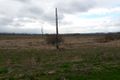
| + | File:2019-02-03 45 -123 North.jpg|...North... | ||
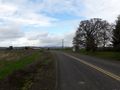
| + | File:2019-02-03 45 -123 East.jpg|...East... | ||
| + | File:2019-02-03 45 -123 South.jpg|...and South from the hashpoint. | ||
</gallery> | </gallery> | ||
== Achievements == | == Achievements == | ||
{{#vardefine:ribbonwidth|800px}} | {{#vardefine:ribbonwidth|800px}} | ||
| − | |||
| − | |||
| − | |||
| − | |||
| − | |||
| − | |||
| − | |||
| − | + | {{Regional geohashing | |
| − | + | | name = Michael5000 | |
| − | + | | region = Yamhill County, Oregon | |
| − | + | | count = 2 | |
| + | | image = M5KYamhill County.jpg | ||
| + | }} | ||
| − | |||
| − | |||
| − | |||
[[Category:Expeditions]] | [[Category:Expeditions]] | ||
| − | |||
[[Category:Expeditions with photos]] | [[Category:Expeditions with photos]] | ||
| − | |||
| − | |||
| − | |||
| − | |||
| − | |||
| − | |||
| − | |||
[[Category:Coordinates reached]] | [[Category:Coordinates reached]] | ||
| − | |||
| − | |||
| − | |||
| − | |||
| − | |||
| − | |||
| − | |||
| − | |||
| − | |||
| − | |||
| − | |||
| − | |||
| − | |||
| − | |||
| − | |||
| − | |||
| − | |||
| − | |||
Revision as of 01:12, 4 February 2019
| Sun 3 Feb 2019 in 45,-123: 45.1288409, -123.2398862 geohashing.info google osm bing/os kml crox |
Location
On Briedwell Road in the farmland northwest of Amity.
Participants
Expedition
The little village of Amity is in agricultural country about an hour's drive southwest of Portland. It's cute. There's a nice park at the southwest edge, and I parked there and ran about two miles to the hashpoint, which was placed with convenient road access. It was unfortunately about the least scenic specific place in the area, but that's where the hashpoint was so that's where I took my pictures. Then, I continued down Briedwell Road to the north, then headed back east to catch the fetchingly named Hook and Eye Road, which let me loop back towards the starting point. It was a very scenic run through orchards and fields, and at 8.13 broke my distance record for Yamhill County. It was also my first expedition to the McMinnville graticule portion of Yamhill County.
Tracklog
Not technically a "Tracklog," but fitting the bill:
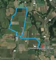
The route that I ran. The hashpoint is on the southwest side of the loop.

Photos
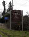
A welcome sign to the village
Looking West...
...North...
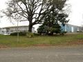
...East...

...and South from the hashpoint.


Achievements
Michael5000 earned the Regional geohashing achievement
|