Difference between revisions of "2019-07-04 47 -122"
imported>Thomcat ([live picture]view of MOHAI [http://www.openstreetmap.org/?lat=47.62671000&lon=-122.33770190&zoom=16&layers=B000FTF @47.6267,-122.3377]) |
imported>Coyotebush (success; my expedition) |
||
| Line 23: | Line 23: | ||
<!-- how it all turned out. your narrative goes here. --> | <!-- how it all turned out. your narrative goes here. --> | ||
| + | === [[User:Coyotebush|coyotebush]] === | ||
*Missed a bus, again. More like 10am. -- [[User:Coyotebush|Coyotebush]] ([[User talk:Coyotebush|talk]]) 09:34, 4 July 2019 (PDT) | *Missed a bus, again. More like 10am. -- [[User:Coyotebush|Coyotebush]] ([[User talk:Coyotebush|talk]]) 09:34, 4 July 2019 (PDT) | ||
| − | + | ||
| − | + | Approaching from the southwest, I found an unexpected fence blocking my way and worried that the park might already have been closed off for the festival that accompanies the July 4 fireworks on Lake Union. Fortunately, a bit farther along was an entrance to the area. No spraypark fountains this overcast morning. I zeroed in on the spot easily enough and found a utility marking that lined up with Google's satellite image. After taking some photos, I caught the streetcar that stops right next to the park and rode nearly the entire mile-long line into downtown to continue my day. | |
| + | |||
== Photos == | == Photos == | ||
| Line 51: | Line 53: | ||
== Achievements == | == Achievements == | ||
{{#vardefine:ribbonwidth|800px}} | {{#vardefine:ribbonwidth|800px}} | ||
| − | |||
| − | |||
| − | |||
| − | |||
| − | |||
| − | |||
| − | |||
| − | |||
| − | |||
| − | |||
| − | |||
| − | + | {{Public transport geohash | |
| + | | latitude = 47 | ||
| + | | longitude = -122 | ||
| + | | date = 2019-07-04 | ||
| + | | name = coyotebush | ||
| + | }} | ||
| − | |||
[[Category:Expeditions]] | [[Category:Expeditions]] | ||
[[Category:Expeditions with photos]] | [[Category:Expeditions with photos]] | ||
[[Category:Coordinates reached]] | [[Category:Coordinates reached]] | ||
| − | |||
| − | |||
| − | |||
| − | |||
| − | |||
| − | |||
| − | |||
| − | |||
| − | |||
| − | |||
| − | |||
Revision as of 03:16, 5 July 2019
| Thu 4 Jul 2019 in Seattle: 47.6263121, -122.3376194 geohashing.info google osm bing/os kml crox |
Location
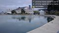
The pedestrian area in front of Lake Union Park, very close to the spraypark.
Participants
Plans
Visit early in the day, because fireworks are planned for the evening here.
- How early? Coyotebush (talk) 20:29, 3 July 2019 (UTC)
- I'll probably be there around 9:30am or so myself. Coyotebush (talk) 04:43, 4 July 2019 (UTC)
Expedition
coyotebush
- Missed a bus, again. More like 10am. -- Coyotebush (talk) 09:34, 4 July 2019 (PDT)
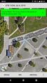
Approaching from the southwest, I found an unexpected fence blocking my way and worried that the park might already have been closed off for the festival that accompanies the July 4 fireworks on Lake Union. Fortunately, a bit farther along was an entrance to the area. No spraypark fountains this overcast morning. I zeroed in on the spot easily enough and found a utility marking that lined up with Google's satellite image. After taking some photos, I caught the streetcar that stops right next to the park and rode nearly the entire mile-long line into downtown to continue my day.
Photos
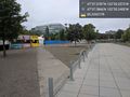
Inside the festival fence @47.6264,-122.3373
Success
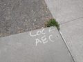
Pre-marked
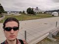
Hasher

Geohasher @47.6263,-122.3376
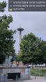
View of the needle @47.6264,-122.3375
view of MOHAI @47.6267,-122.3377


Achievements
coyotebush earned the Public transport geohash achievement
|