Difference between revisions of "2020-09-17 45 4"
From Geohashing
m (Location) |
(→Photos) |
||
| Line 14: | Line 14: | ||
== Photos == | == Photos == | ||
<gallery perrow="5"> | <gallery perrow="5"> | ||
| + | Image:2020-09-17 45 4 01.jpg | Arriving by train in Givors | ||
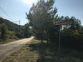
| + | Image:2020-09-17 45 4 02.jpg | Walking out of Givors toward Saint-Romain-en-Gier | ||
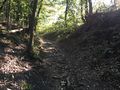
| + | Image:2020-09-17 45 4 03.jpg | A little bit of climbing | ||
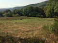
| + | Image:2020-09-17 45 4 04.jpg | The coordinates are in this meadow. | ||
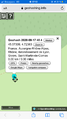
| + | Image:2020-09-17 45 4 05.png | Coordinates reached | ||
| + | Image:2020-09-17 45 4 06.jpg | A geohash in a haystack | ||
| + | Image:2020-09-17 45 4 07.jpg | Stupid grin | ||
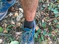
| + | Image:2020-09-17 45 4 08.jpg | I couldn't not do this. | ||
| + | Image:2020-09-17 45 4 09.jpg | Oops! Wrong path. | ||
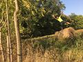
| + | Image:2020-09-17 45 4 10.jpg | Aftermath of a Raptor attack | ||
</gallery> | </gallery> | ||
Revision as of 13:00, 18 September 2020
| Thu 17 Sep 2020 in 45,4: 45.5733916, 4.7236349 geohashing.info google osm bing/os kml crox |
Location
In a meadow near Saint-Romain-en-Gier.
Participants
Expedition
Photos

Arriving by train in Givors
Walking out of Givors toward Saint-Romain-en-Gier
A little bit of climbing
The coordinates are in this meadow.
Coordinates reached
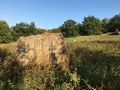
A geohash in a haystack

Stupid grin
I couldn't not do this.
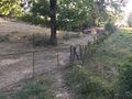
Oops! Wrong path.
Aftermath of a Raptor attack


Achievements
Baarde earned the Land geohash achievement
|