Difference between revisions of "2016-06-14 42 -111"
From Geohashing
m (Removing expedition planning category) |
|||
| Line 53: | Line 53: | ||
<!-- Add any achievement ribbons you earned below, or remove this section --> | <!-- Add any achievement ribbons you earned below, or remove this section --> | ||
| − | |||
| − | |||
| − | |||
| − | |||
| − | |||
| − | |||
| − | |||
| − | |||
| − | |||
| − | |||
| − | |||
| − | |||
| − | |||
| − | |||
[[Category:Expeditions]] | [[Category:Expeditions]] | ||
| − | |||
[[Category:Expeditions with photos]] | [[Category:Expeditions with photos]] | ||
| − | |||
| − | |||
| − | |||
| − | |||
| − | |||
[[Category:Coordinates reached]] | [[Category:Coordinates reached]] | ||
| − | |||
| − | |||
| − | |||
| − | |||
| − | |||
| − | |||
| − | |||
| − | |||
| − | |||
| − | |||
| − | |||
| − | |||
| − | |||
| − | |||
| − | |||
| − | |||
| − | |||
| − | |||
{{location|US|ID|CR}} | {{location|US|ID|CR}} | ||
Latest revision as of 09:55, 7 September 2021
| Tue 14 Jun 2016 in 42,-111: 42.6562954, -111.7977129 geohashing.info google osm bing/os kml crox |
Location
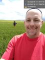
In an agricultural field close to a road west of Soda Springs.
Participants
- Bravissimo594 (talk)
- Boppy5
Plans
Boppy5 and I might be able to hit it on the way to pick up a friend in Pocatello. Bravissimo594 (talk) 16:07, 14 June 2016 (UTC)
Expedition
Tracklog
Photos
Made it! @42.6563,-111.7977
On the spot, with Boppy5 following. @42.6562,-111.7986

