Difference between revisions of "2021-10-26 40 -4"
m (Location) |
|||
| Line 71: | Line 71: | ||
<!-- An actual expedition: --> | <!-- An actual expedition: --> | ||
[[Category:Expeditions]] | [[Category:Expeditions]] | ||
| − | |||
| − | |||
| − | |||
| − | |||
| − | |||
| − | |||
| − | |||
[[Category:Expeditions with photos]] | [[Category:Expeditions with photos]] | ||
| − | + | [[Category:Coordinates not reached]] | |
| − | |||
<!-- When there is a man-made obstacle between you and the | <!-- When there is a man-made obstacle between you and the | ||
Latest revision as of 11:04, 1 November 2021
| Tue 26 Oct 2021 in 40,-4: 40.4006572, -4.2206172 geohashing.info google osm bing/os kml crox |
Location
In the wilds, near Chapinería.
Participants
Plans
Expedition
It was a spontaneous decision to try this one in the late afternoon after work. I wanted to be back home before dark, so time was quite limited and I did not take many photos along the way.
I ended up at a closed gate. Like in expedition 2021-10-12_40_-4, there was a sign requesting to keep the gate closed, which I would again interpret as permission to open it to slip through, however, this one was securely locked. It could have been that the geohash was in fact beyond the fenced area and I could have walked around it, but the Sun was already quite low, so I was thinking that this would take too much time and I gave up at that point.
Checking it later thoroughly on the Maps showed that the geohash was indeed outside of the fenced area but that it would have been a substantial detour to walk around it. So, I was not unhappy with the decision to give up at the gate. At least I brought home a photo I like a lot.
Tracklog
Photos
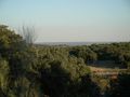
Nice view while walking through the wilds.
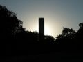
Water tower in back light, conveying the evening atmosphere.
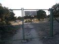
Here it ends this time. I turn around and walk back.


