Difference between revisions of "2021-11-18 51 9"
From Geohashing
(expedition report for the B 251) |
m (Location) |
||
| Line 35: | Line 35: | ||
[[Category:Coordinates reached]] | [[Category:Coordinates reached]] | ||
| + | {{location|DE|HE|KS}} | ||
Latest revision as of 01:42, 24 November 2021
| Thu 18 Nov 2021 in 51,9: 51.2868760, 9.1742496 geohashing.info google osm bing/os kml crox |
Location
The hash lay on the national road 251 between Bründersen and Ippinghausen.
Participants
Expedition
On a way to an errand I made a detour with a bus. I took the bus 110 at Kassel-Wilhelmshöhe to Wolfhagen.
Tracklog
Photos
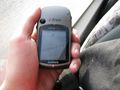
accidentally got a zero meter shot
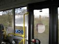
looking right
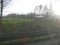
looking left


